
Quick Facts: Hiking in Saudi Arabia
- Best season: October to March (10-25°C in most regions)
- Highest peak: Jebel Sawda, Asir Mountains — 3,015 m (9,892 ft)
- Most famous hike: Edge of the World (Jebel Fihrayn), 90 km northwest of Riyadh
- Governing body: Saudi Climbing and Hiking Federation (SCHF)
- Difficulty range: Easy family walks to challenging multi-hour mountain ascents
- 4×4 required: Yes, for most trailheads outside urban areas
- Wild camping: Permitted on most open desert land; permits needed for national parks and royal reserves
- Visa: Tourist e-visa available for 49+ nationalities
Saudi Arabia is not the first country most people associate with hiking. The mental image tends to stop at flat desert and relentless heat. That image is wrong. The Kingdom contains a startling diversity of terrain — from 3,000-metre juniper-clad peaks in the southwest to 300-metre sandstone cliffs an hour from Riyadh, from waterfall-fed canyons in the far south to volcanic craters west of Taif. As the country opens to international tourism under Vision 2030, its trail network is expanding rapidly, and the Saudi Climbing and Hiking Federation is certifying new routes and guides every year.
This guide covers the essential hiking destinations across the Kingdom, from beginner-friendly desert walks to serious mountain ascents. Whether you are planning a day trip from Riyadh or a multi-day expedition through the Asir highlands near Abha, the information below will help you choose the right trail, pack the right gear, and stay safe in conditions that reward preparation and punish complacency.
The Edge of the World (Jebel Fihrayn)
No list of Saudi hikes begins anywhere else. Jebel Fihrayn — universally known as the Edge of the World — is a section of the Tuwaiq Escarpment roughly 90 kilometres northwest of Riyadh where 300-metre sandstone cliffs drop abruptly into a vast, ancient seabed. The visual effect is extraordinary: you stand at the lip of a plateau and look out across a horizon so flat and so far below that the name feels earned rather than exaggerated.
Getting there
The drive from central Riyadh takes approximately two hours. The first portion follows paved highways, but the final 30 to 40 kilometres cross unmarked, rocky desert terrain. A 4×4 vehicle is not optional — sedans will not survive the approach. Many visitors join guided tours that handle navigation and transport, which is worth considering if you are unfamiliar with off-road desert driving. Tour operators such as Riyadh Hiking and 365 Adventures run regular excursions.
The hike itself
The trail from the parking area to the cliff edge is relatively short — roughly 1.5 to 2 kilometres one way — and manageable for most fitness levels, including families with older children. The terrain involves light scrambling over rocks, but nothing that requires technical skill. The reward is the view: a sheer drop into a valley strewn with fossilised coral, dried riverbeds, and the occasional camel caravan far below.
Sunset is the most popular time, and for good reason. The golden light transforms the escarpment into layers of amber and copper, and shadows stretch for kilometres across the desert floor. Arrive at least two hours before sunset to explore the cliff edge and find a vantage point.
Trail details
| Detail | Information |
|---|---|
| Distance | 3-4 km round trip (cliff edge trail) |
| Elevation | 1,131 m at the escarpment |
| Difficulty | Easy to moderate |
| Duration | 2-3 hours on site (plus 2-hour drive each way) |
| Best time | October to March; late afternoon for sunset |
| Vehicle | 4×4 required |
Jebel Sawda and the Asir Mountains
If the Edge of the World is Saudi Arabia’s most famous hike, Jebel Sawda is its most serious one. Rising to an officially recognised 3,015 metres above sea level in the Asir region near Abha, it is the highest point in the Kingdom — and one of the few places in Saudi Arabia that feels nothing like the Arabian Peninsula’s popular image.
The Asir Mountains are green. Juniper forests coat the slopes, wildflowers bloom in spring, and mist rolls through the valleys in the cooler months. Temperatures here can drop to single digits in winter, a world apart from the 45°C summers of the lowland deserts. The region receives more rainfall than anywhere else in Saudi Arabia, and the landscape reflects it.
The Jebel Sawda trail
The main trail up Jebel Sawda is one of the best-maintained hiking paths in the Kingdom. It covers approximately 14.5 kilometres with a significant elevation gain of over 1,000 metres, and takes six to seven hours to complete. The route begins in dry, cactus-studded terrain, passes through a transition zone of mossy forest, and emerges onto a ridgeline with panoramic views across the Sarawat Range toward the Red Sea coast.
This is a genuinely challenging hike. The elevation gain is sustained, the trail surface is uneven in sections, and altitude can affect those not acclimatised. Bring layers — the temperature at the summit can be 15 to 20 degrees cooler than Abha itself.
Trail details
| Detail | Information |
|---|---|
| Distance | ~14.5 km (out and back) |
| Elevation | 3,015 m summit |
| Elevation gain | ~1,050 m |
| Difficulty | Hard |
| Duration | 6-7 hours |
| Best time | October to April |
| Nearest city | Abha (20 km) |
Other Asir trails
The broader Asir region offers several additional hiking options beyond the Jebel Sawda summit. The Al Soudah area has developed walking paths and viewpoints accessible to casual walkers, and the Asir National Park provides shorter loop trails through juniper forest. For those based in Abha, the escarpment trails along the western edge of the plateau offer dramatic cliff-edge walking with views down to the Tihama coastal plain thousands of metres below.
Wadi Disah — The Valley of Palm Trees
Wadi Disah in the Tabuk region of northwestern Saudi Arabia is arguably the most visually dramatic canyon hike in the Kingdom. Often called the Valley of Palm Trees, it is a 15-kilometre-long canyon flanked by sandstone walls that rise up to 400 metres, their surfaces carved by millennia of wind and water into flowing, organic shapes. The canyon floor is dotted with palm groves, freshwater springs, and seasonal streams that create an unexpectedly lush environment within the desert.
Hiking the canyon
The most rewarding way to experience Wadi Disah is on foot. You can park at the canyon entrance and walk in, following the watercourse through narrowing walls and past hidden pools. The full length of the canyon is approximately 15 kilometres, but most day hikers cover a portion of this, turning back after three to five hours.
The terrain is generally flat but uneven — expect river rocks, occasional wading through shallow water (depending on season), and sections where the trail narrows between boulders. It is not technically difficult, but the distance and heat exposure make it moderately demanding. A 4×4 vehicle can drive partway into the canyon, which is useful for those who want to reach the more dramatic inner sections without the full approach walk.
Trail details
| Detail | Information |
|---|---|
| Distance | Up to 15 km one way (full canyon length) |
| Canyon wall height | Up to 400 m |
| Difficulty | Easy to moderate |
| Duration | 3-5 hours (partial); full day for complete traverse |
| Best time | November to March |
| Nearest city | Tabuk (215 km) |
| Vehicle | 4×4 required for approach and canyon driving |
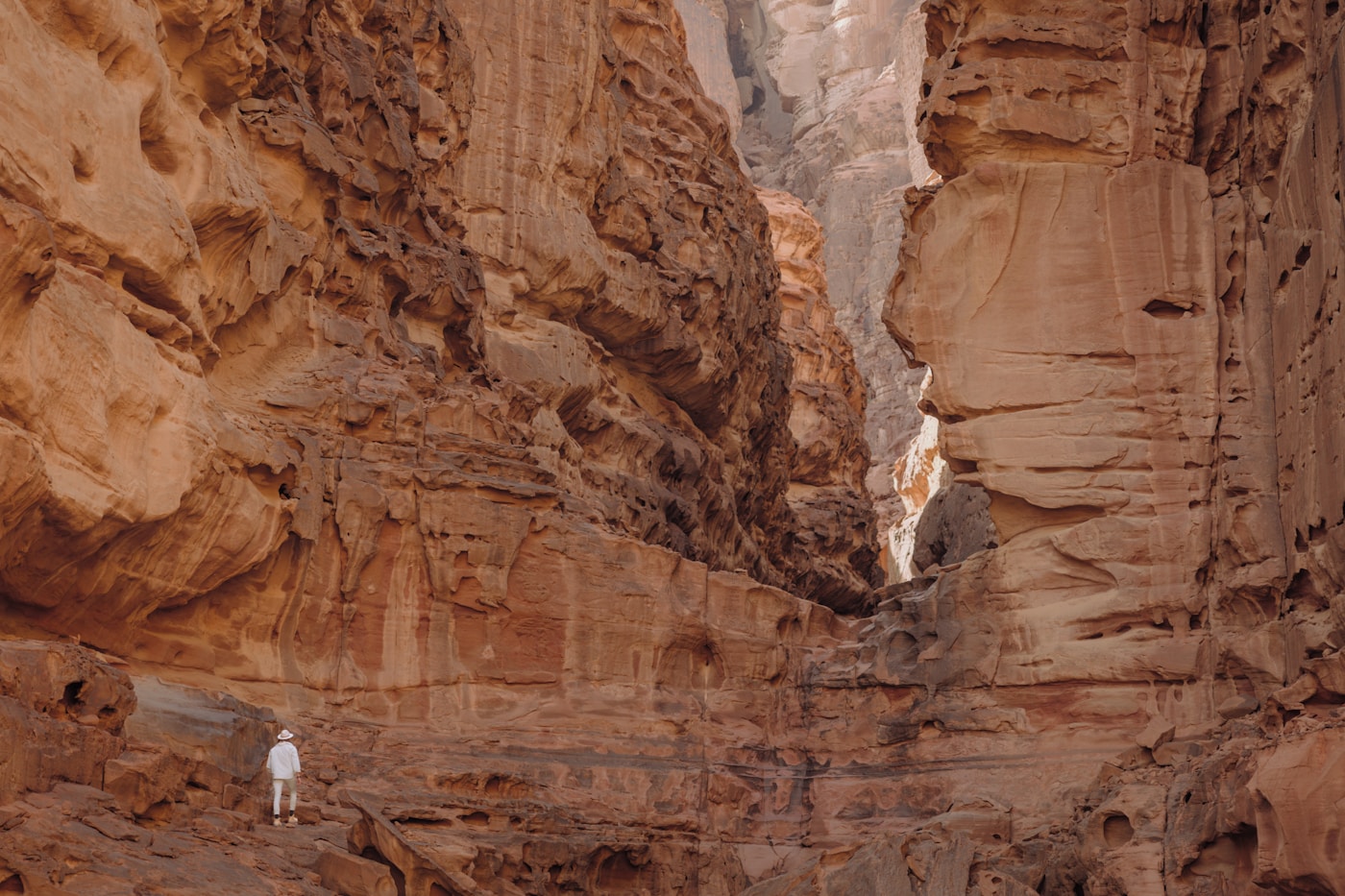
Wadi Lajab — The Hidden Paradise
Wadi Lajab in the Jizan region of Saudi Arabia’s far southwest is unlike any other hiking destination in the Kingdom. This narrow canyon — roughly five kilometres long and as narrow as three metres in places — is wedged between cliff walls that rise 300 to 800 metres overhead, blocking sunlight and creating a microclimate more reminiscent of a tropical ravine than the Arabian Peninsula.
What makes Wadi Lajab exceptional is water. Unlike the dry wadis that characterise most of Saudi Arabia, Wadi Lajab contains a permanent stream fed by mountain springs. The water creates small waterfalls, pools deep enough to swim in, and supports an astonishing density of vegetation — hanging palms, ferns, moss-covered rocks, and vines growing from cracks in the canyon walls.
Hiking the wadi
The hike through Wadi Lajab is essentially a canyon walk along the streambed. You will get wet. In some sections, the water is ankle-deep; in others, you may need to wade through thigh-deep pools. The footing is rocky and slippery, and the canyon narrows in places to the point where you are squeezing between walls.
The full exploration takes four to five hours. Start early — the 120-kilometre drive from Jizan city takes roughly two hours on roads that deteriorate significantly in the final stretch, and a 4×4 is essential. Local guides are available at the entrance and are worth hiring, particularly for first-time visitors unfamiliar with the canyon’s layout and water conditions.
Trail details
| Detail | Information |
|---|---|
| Distance | ~5 km one way |
| Canyon depth | 300-800 m walls |
| Difficulty | Moderate (water crossings, slippery terrain) |
| Duration | 4-5 hours |
| Best time | November to March |
| Nearest city | Jizan (120 km) |
| Water | Permanent stream; expect to wade |
Al Hada and the Hejaz Mountains
The Hejaz Mountains form the western spine of the Arabian Peninsula, running from the Gulf of Aqaba in the north southward past Mecca and Taif. For hikers, the most accessible section is around Al Hada, a mountain area roughly 20 kilometres northwest of Taif that rises above 2,000 metres and offers a welcome escape from the heat of the lowlands.
Kara Heritage Trail
The standout route in this region is the Kara Heritage Trail, a historic path that winds between Mecca and Taif through the mountains and valleys surrounding Al Hada. The trail follows ancient caravan routes and offers panoramic views of Jabal Al Hada at 2,000 metres. The terrain is rocky and exposed in sections, with moderate elevation changes that make it suitable for experienced hikers rather than complete beginners.
Al Hada itself has developed tourist infrastructure, including a 4.2-kilometre cable car that descends from the summit area to the Al Kar Tourist Village below. This is useful for those who want dramatic mountain views without a strenuous hike, and it provides a sense of the escarpment’s scale that is difficult to appreciate from ground level.
Taif area hiking
The broader Taif area, accessible from Jeddah via a spectacular mountain road, offers additional walking opportunities. The Shafa area south of Taif has developing trail networks through terraced agricultural landscapes, and the rose farms that Taif is famous for make pleasant destinations for shorter walks, particularly during the spring rose harvest in March and April.
Al Wahbah Crater
Al Wahbah Crater sits on the western edge of the Harrat Kishb basalt plateau, roughly 250 kilometres from Taif. It is a maar crater — formed not by a meteorite impact, as was long believed, but by a massive steam explosion when molten basalt encountered underground water. The result is a near-perfect circular depression two kilometres in diameter and 250 metres deep, with a floor covered in white sodium phosphate crystals that shimmer in the sunlight.
Hiking options
There are two main hiking experiences at Al Wahbah. The rim walk follows the circumference of the crater and takes approximately three hours — a moderately demanding hike with constantly shifting views of the crater interior and the surrounding lava fields. The descent to the crater floor is steeper: roughly 45 minutes down and 90 minutes back up, with a scramble over loose volcanic rock that requires reasonable fitness and sturdy footwear.
Note that access to the crater floor has been restricted at various times due to safety concerns — hikers have struggled with the ascent in high temperatures. Check current regulations before planning a descent, and regardless of rules, do not attempt it in summer or without at least three litres of water per person.
Trail details
| Detail | Information |
|---|---|
| Crater diameter | 2 km |
| Crater depth | 250 m |
| Rim walk | ~6 km circumference; 3 hours |
| Descent to floor | 45 min down, 90 min up |
| Difficulty | Moderate (rim); hard (descent) |
| Best time | October to April |
| Nearest city | Taif (250 km) |
The Tuwaiq Escarpment — Beyond the Edge of the World
The Edge of the World at Jebel Fihrayn is the most visited section of the Tuwaiq Escarpment, but the escarpment itself runs approximately 800 kilometres from Al-Qasim in the north to the edge of the Rub’ al Khali desert in the south. Much of this vast geological feature remains unexplored by casual hikers, and that is precisely its appeal for those seeking solitude.
Several sections of the escarpment beyond Jebel Fihrayn offer dramatic cliff-edge hiking with comparable views but a fraction of the visitors. The escarpment south of Riyadh, in particular, has developing trail access and fewer tour groups. However, navigation is challenging — marked trails are limited, mobile phone signal is unreliable, and the terrain is remote enough that a breakdown or injury becomes a serious logistical problem. This is territory for experienced desert hikers who travel in groups and carry proper communication equipment.
Rock Climbing in Saudi Arabia
Saudi Arabia’s rock climbing scene has grown substantially in recent years, driven by the Saudi Climbing and Hiking Federation (SCHF) and a growing community of local and expatriate climbers. The Kingdom’s geology — sandstone, granite, and basalt in various formations — provides excellent climbing terrain across multiple regions.
Key climbing areas
Tanomah, Asir Mountains: The premier climbing destination in Saudi Arabia. Located at approximately 2,200 metres altitude, Tanomah offers granite cliffs and boulders with over 40 established routes ranging from beginner-friendly 4s to challenging 8b grades. The SCHF has identified three main crags here: Wall of Shadows, Al Sharaf, and The Book. Al Sharaf Park, just ten minutes from central Tanomah, is the most accessible and features favourable year-round temperatures.
Al Shafa, Taif: The Olympic Crag at Al Shafa Centre offers sport climbing routes on good-quality rock with relatively easy access from Taif.
Wadi Al Akhu, Riyadh: A crag within reasonable driving distance of the capital, useful for Riyadh-based climbers looking for regular practice sessions.
AlUla, Medina region: The sandstone formations around AlUla are visually spectacular for climbing, though route development is still in its early stages.
The SCHF issues licences for climbing guides and coaches, and their website (climbing.sa) maintains a list of certified guides and upcoming events. For visiting climbers, connecting with the federation is the best way to find partners and access current route information.
Mountain Biking
Mountain biking is an emerging outdoor activity in Saudi Arabia, with the most developed trail networks in the AlUla region. AlUla offers 26 kilometres of continuous trail from the Wheels Bike Hub to the Hegra Visitor Centre, passing through date palm groves, dramatic canyons, and sandstone formations. An expanded 80-kilometre bike path network is under development.
Guided mountain biking tours in AlUla provide bikes and safety equipment, making it accessible to visitors who do not want to transport their own gear. The terrain varies from smooth gravel paths suitable for casual riders to technical off-road sections that will challenge experienced mountain bikers.
The annual AlUla Tour, a UCI World Tour cycling event, has raised the region’s profile among serious cyclists. While this is a road racing event, the infrastructure and attention it brings benefit the broader cycling ecosystem in the area.
For informal mountain biking, the desert trails around Riyadh and the mountain roads near Taif and Abha offer opportunities, though organised trail networks outside AlUla remain limited. A rental vehicle with a bike rack is the practical approach for self-guided cycling exploration.
When to Go: Seasonal Planning
The hiking season in Saudi Arabia is dictated almost entirely by heat. The optimal window runs from October through March, when daytime temperatures in most regions settle between 10 and 25 degrees Celsius. Within that window, conditions vary by region and altitude.
Season breakdown
| Period | Conditions | Best regions |
|---|---|---|
| October – November | Warm days (20-30°C), cool evenings. Transition season — still hot at lower elevations. | Asir Mountains, Al Hada, Wadi Lajab |
| December – February | Peak season. Cool to mild (10-25°C). Possible frost at high altitude. Best overall conditions. | All regions; Edge of the World, Wadi Disah, Al Wahbah Crater |
| March – April | Warming rapidly. Still acceptable for mountain areas. Wildflower season in Asir. | Asir Mountains, Taif area, high-altitude trails |
| May – September | Dangerous heat at low elevations (40-50°C). Only high-altitude Asir remains viable. | Jebel Sawda and Soudah area only |
Ramadan affects logistics more than conditions. Restaurants and shops may have reduced hours, and guided tours may be less available. Plan accordingly.
Trail Difficulty Comparison
The following table compares the major trails covered in this guide to help with planning.
| Trail | Region | Difficulty | Distance | Duration | 4×4 Needed |
|---|---|---|---|---|---|
| Edge of the World | Riyadh | Easy-Moderate | 3-4 km | 2-3 hours | Yes |
| Jebel Sawda Summit | Asir | Hard | 14.5 km | 6-7 hours | No |
| Wadi Disah (full) | Tabuk | Easy-Moderate | 15 km | Full day | Yes |
| Wadi Lajab | Jizan | Moderate | 5 km | 4-5 hours | Yes |
| Al Wahbah Rim Walk | Taif | Moderate | 6 km | 3 hours | Yes |
| Al Wahbah Descent | Taif | Hard | 1 km | 2.5 hours | Yes |
| Kara Heritage Trail | Taif | Moderate | Varies | 3-5 hours | No |
| Tuwaiq Escarpment | Central | Hard | Varies | Full day | Yes |
What to Bring: Essential Gear
Packing for Saudi hiking requires balancing sun protection, hydration, and the possibility of surprisingly cold conditions at altitude or after dark.
The essentials
- Water: A minimum of three litres per person for a half-day hike; six to eight litres for a full day in desert conditions. Hydration bladders are more practical than bottles for longer trails.
- Sun protection: High-SPF sunscreen (50+), UV-blocking sunglasses, and a wide-brimmed hat or headscarf. The desert sun is punishing, and reflected light from rock and sand intensifies exposure.
- Footwear: Sturdy hiking boots with good ankle support and grippy soles. The terrain across most Saudi trails involves loose rock, sand, and in the case of wadis, water crossings. Trail running shoes may suffice for easier routes, but boots are recommended for the majority of hikes in this guide.
- Clothing: Light-coloured, loose-fitting, long-sleeved shirts and trousers in breathable fabric. This protects against sun and scrub while maintaining airflow. For mountain hikes above 2,000 metres or any evening activity, pack a medium-weight insulating layer — temperatures drop rapidly after sunset.
- Navigation: A downloaded offline map (Google Maps or Maps.me) is essential. Mobile phone signal is unreliable at most trailheads. A GPS device or compass and paper map are prudent for remote routes along the Tuwaiq Escarpment or deep canyon hikes.
- First aid kit: Including blister treatment, antiseptic, bandages, electrolyte sachets, and any personal medications. The nearest hospital may be hours away from remote trailheads.
- Emergency communication: For remote hikes, a satellite communicator (such as a Garmin inReach) provides a safety net that mobile phones cannot match.
- Snacks: High-energy food — nuts, dried fruit, energy bars — and salty snacks to maintain electrolyte balance.
For canyon hikes (Wadi Lajab, Wadi Disah)
- Water shoes or sandals with good grip for stream crossings
- Dry bag for electronics and valuables
- Quick-dry clothing
- Insect repellent — canyon environments harbour more insects than open desert
Safety and Desert Hiking Considerations
Desert and mountain hiking in Saudi Arabia presents hazards that differ from what most visitors are accustomed to. Respect for the environment and honest self-assessment of fitness and experience are the foundations of safe hiking here.
Heat management
Heat is the primary danger for most Saudi hikes. Between April and October, midday temperatures at lower elevations regularly exceed 40 degrees Celsius, and ground-level temperatures on exposed rock or sand can reach 60 degrees. Even during the cooler season, midday sun is intense. Plan to be on the trail by 6:00 or 7:00 AM, aim to finish strenuous sections before 11:00 AM, and avoid exposed hiking between 11:00 AM and 4:00 PM whenever possible.
Signs of heat exhaustion — headache, nausea, heavy sweating followed by cessation of sweating, confusion — require immediate action: move to shade, cool the body with water, and hydrate. Heat stroke is a medical emergency. Sip water consistently rather than drinking large quantities infrequently, and supplement with electrolytes.
Wildlife
Snakes and scorpions are present across Saudi Arabia’s hiking terrain. Watch where you place your hands when scrambling, check inside boots before putting them on in the morning if camping, and use a torch at night. Baboons are common in the Asir Mountains and can be aggressive around food — secure your provisions and maintain distance.
Flash floods
Wadis are dry riverbeds. They exist because they flood. During the rainy season (typically November through March in much of Saudi Arabia), a rainstorm many kilometres away can send a wall of water through a wadi with little warning. Never camp in the floor of a wadi, monitor weather forecasts, and if you hear rumbling or see water levels rising, move to high ground immediately. Wadi Lajab and Wadi Disah are both susceptible to flash flooding.
Navigation and communication
Marked trails are the exception rather than the rule in Saudi Arabia. Outside the Jebel Sawda area and a few developed sites, you are likely navigating by GPS waypoints, cairns, or simply by sight. The desert landscape can be disorienting — one rocky hill looks much like the next — and losing your bearings in remote terrain is a serious situation. Travel in groups of at least two vehicles for remote desert hikes, inform someone of your plans and expected return time, and carry a satellite communicator on any route that takes you beyond mobile phone coverage.
Guided vs Independent Hiking
The choice between guided and independent hiking in Saudi Arabia depends on your experience level, the specific trail, and your comfort with desert navigation.
When a guide adds real value
- Edge of the World: The unmarked desert approach is the main challenge. A guided tour eliminates the navigation problem and provides transport.
- Wadi Lajab: Local guides know the canyon layout, water conditions, and safe passages. Worth the investment for first-time visitors.
- Remote Tuwaiq Escarpment: Extended hiking along unmarked sections of the escarpment is not advisable without local knowledge.
- Rock climbing: The SCHF-certified guides at Tanomah and other crags are essential unless you are an experienced climber with your own gear and route knowledge.
When independent hiking works well
- Jebel Sawda: The trail is well-marked and well-maintained. A guide is unnecessary for experienced hikers.
- Wadi Disah: The canyon is a relatively straightforward follow-the-water hike. A 4×4 vehicle and basic navigation skills are sufficient.
- Al Wahbah Crater: The rim is visible from distance and the trail is obvious. Navigation is not an issue.
- Al Hada area: Good road access and tourist infrastructure make independent exploration practical.
The Saudi Climbing and Hiking Federation (climbing.sa) maintains a list of licensed guides and organises regular events and group hikes. For visitors, these events are an excellent way to meet experienced local hikers and gain access to trails that are difficult to find independently.
Camping at Trailheads
Camping is a natural companion to hiking in Saudi Arabia, and the Kingdom’s regulations are relatively permissive. Wild camping is permitted on most open desert land without a permit, provided you avoid private property, military zones, and protected reserves. For designated camping areas within national parks or royal reserves, digital permits can be obtained through the National Center for Vegetation Cover’s online platform.
Practical camping advice for Saudi trailheads:
- Al Wahbah Crater: The rim is an outstanding camping location. No facilities exist, but the absence of light pollution makes it one of the best stargazing sites in the Kingdom.
- Edge of the World: Camping on the escarpment is popular and atmospheric. Bring all water and supplies — there is nothing at the site.
- Wadi Disah: Camping within the canyon is possible and beautiful, but be aware of flash flood risk. Camp on elevated ground, never on the canyon floor in wet season.
- Asir Mountains: Developed campgrounds exist near Al Soudah. Temperatures can drop significantly at night, so a proper sleeping bag rated for near-freezing conditions is advisable from November to February.
The environmental rules are strict and enforced: leave no trace, do not use local firewood or charcoal (penalties apply), and carry all rubbish out. The desert ecosystem is fragile, and vehicle damage to vegetation cover carries fines.
Frequently Asked Questions
Do I need a permit to hike in Saudi Arabia?
Most hiking in Saudi Arabia does not require a permit. You can freely access open desert and mountain trails. However, designated national parks, royal reserves, and some protected areas require a digital permit that can be obtained online through the National Center for Vegetation Cover. Always check current regulations for specific sites before travelling.
Is it safe to hike alone in Saudi Arabia?
Solo hiking is not recommended for most Saudi trails, particularly in remote desert areas. The combination of extreme heat, limited mobile phone coverage, unmarked trails, and distance from medical facilities makes solo hiking a significant risk. If you do hike alone, inform someone of your planned route and return time, carry a satellite communicator, and stick to well-established trails like Jebel Sawda.
What is the most beginner-friendly hike in Saudi Arabia?
The Edge of the World (Jebel Fihrayn) is the most accessible option for beginners. The trail is short, the terrain is manageable, and guided tours handle the logistics. Wadi Disah is another good choice for beginners — the canyon floor is relatively flat, and you can turn back at any point. For those near Riyadh, the Wadi Hanifah trail offers easy urban-fringe walking.
Can women hike freely in Saudi Arabia?
Yes. Women can hike independently in Saudi Arabia. There are no legal restrictions on women participating in outdoor activities. The Saudi Climbing and Hiking Federation actively promotes women’s participation in hiking and climbing, and several tour operators offer women-only hiking groups. Standard modest dress is expected in public areas, but practical hiking clothing is acceptable on the trail.
Do I need a 4×4 vehicle for every hike?
Not every hike, but most. Jebel Sawda, the Kara Heritage Trail near Taif, and the Al Hada area are accessible by regular vehicle. However, the Edge of the World, Wadi Disah, Wadi Lajab, Al Wahbah Crater, and most Tuwaiq Escarpment access points require a 4×4. Renting a suitable vehicle is essential for a multi-destination hiking trip.
Is there mobile phone signal on the trails?
Signal is unreliable at most trailheads and non-existent in many canyons and remote desert areas. Download offline maps before leaving your accommodation, and carry a satellite communicator for any hike that takes you more than a few hours from a paved road. Jebel Sawda and Al Hada generally have reasonable coverage; the Edge of the World and remote wadi canyons do not.
Can I combine hiking with a desert safari?
Absolutely. Many tour operators offer combination packages that include desert hiking along with 4×4 dune driving, camel rides, and overnight desert camping. The Riyadh region is particularly well set up for this, with the Edge of the World hike easily combined with a half-day desert safari experience. For multi-day trips, a route linking the Edge of the World, Al Wahbah Crater, and the Taif mountains creates an excellent varied itinerary.
What fitness level do I need?
It depends entirely on the trail. The Edge of the World requires nothing more than the ability to walk on uneven ground for an hour. Jebel Sawda demands genuine hill-fitness and stamina for a six-to-seven-hour hike with over 1,000 metres of elevation gain. Wadi Lajab requires comfort with slippery, wet terrain. Be honest about your fitness, start with easier trails if uncertain, and remember that heat saps energy faster than altitude or distance.