
Wadi Disah — known locally as the Valley of Palms — is a 15-kilometre canyon that cuts through the Jebel Qaraqir sandstone massif in Tabuk Province, northwestern Saudi Arabia. With cliff walls rising up to 500 metres, year-round freshwater springs, dense palm groves and Nabataean rock-cut tombs, it is one of the most visually dramatic natural sites in the Kingdom. Often called the Grand Canyon of Saudi Arabia, the valley sits roughly 220 kilometres southwest of Tabuk city and forms a centrepiece of any Saudi Arabia hiking itinerary. Whether you are a day hiker, a wild camper or an archaeology enthusiast, this guide covers everything you need to plan a trip to Wadi Disah in 2026.
Best Time to Visit: November to March (mild days of 12–25 °C; wildflowers peak in March–April)
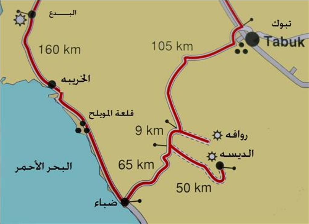
Getting There: 2.5–3 hour drive from Tabuk via Route 8900; 4WD needed for inner canyon
Visa Required: Yes — tourist e-visa
Budget: USD 30–80/day (camping is free; local 4×4 guide ~SAR 200–300)
Must-See: Sandstone canyon walls, Nabataean tomb facades, freshwater palm oasis
Avoid: Visiting June–September when temperatures exceed 40 °C and flash flood risk rises
Why Wadi Disah Deserves a Place on Your Itinerary
Saudi Arabia’s northwest is rapidly emerging as an adventure travel corridor. While Tabuk serves as the gateway city and NEOM grabs headlines, Wadi Disah delivers something quieter and arguably more rewarding: a canyon ecosystem where red Quweira sandstone has been sculpted by wind and water into towering pillars, natural arches and smooth-walled gorges. Freshwater springs feed dense stands of date palms, tamarisk, oleander and papyrus — a green ribbon running through an otherwise arid landscape.
The valley was added to UNESCO’s tentative World Heritage list in 2023 as part of the “Bioclimatic Refuges of Western Arabia” nomination, recognising its ecological significance as a relict environment where plants and animals survive in conditions found nowhere else on the Arabian Peninsula. In 2018, the Public Investment Fund incorporated the Wadi Disah area into the Prince Mohammed bin Salman Nature Reserve, signalling long-term conservation and controlled tourism development.
For visitors exploring the wider Tabuk region, Wadi Disah pairs naturally with trips to the Red Sea coast at Sharma, the snow-dusted peaks of Jabal al-Lawz in winter and the ancient Nabataean sites that connect this area to AlUla and Petra in Jordan.
Geology and Landscape
The canyon runs roughly northeast to southwest through the Jebel Qaraqir massif. Its walls are composed primarily of Quweira sandstone — a Cambrian-era formation that appears in vivid bands of red, ochre and cream. Over millennia, seasonal flash floods carved the main channel while persistent wind erosion created the mushroom rocks, pedestals and honeycomb weathering patterns that line the canyon floor.
At its narrowest points, the gorge squeezes to less than 20 metres across with vertical walls on both sides. At its widest, the valley opens into broad basins where cultivated plots and palm groves sit against the cliff bases. The overall elevation of the wadi floor is approximately 400 metres above sea level, making it cooler than the surrounding desert plains — particularly welcome during shoulder-season visits.
Flora and Fauna
The combination of year-round freshwater springs and sheltered canyon walls creates a microclimate that supports a surprising diversity of plant life. Dense stands of date palms line the watercourses, interspersed with tamarisk trees, jujube shrubs, mint, henna bushes and wild citrus. Pink oleander grows among the boulders, and sedge and papyrus — plants more commonly associated with the Nile — thrive along the permanent streams.
Birdlife is particularly rich. The canyon attracts migrating species in spring and autumn, while resident raptors patrol the cliff tops year-round. Keep watch for Bonelli’s eagle, Egyptian vultures and various desert wheatear species. On the ground, Arabian gazelles have been sighted in the broader valley, and the Prince Mohammed bin Salman Nature Reserve is actively working to restore populations of ibex and other native species. Smaller fauna include rock hyrax, desert hedgehogs and a variety of lizard species that sun themselves on the warm sandstone.
History and Archaeology
Wadi Disah was not always a hiking destination — for thousands of years, it was a settlement corridor. The valley’s permanent water supply made it a natural stop on ancient trade routes connecting the Red Sea port of Duba to the interior.
Nabataean Heritage
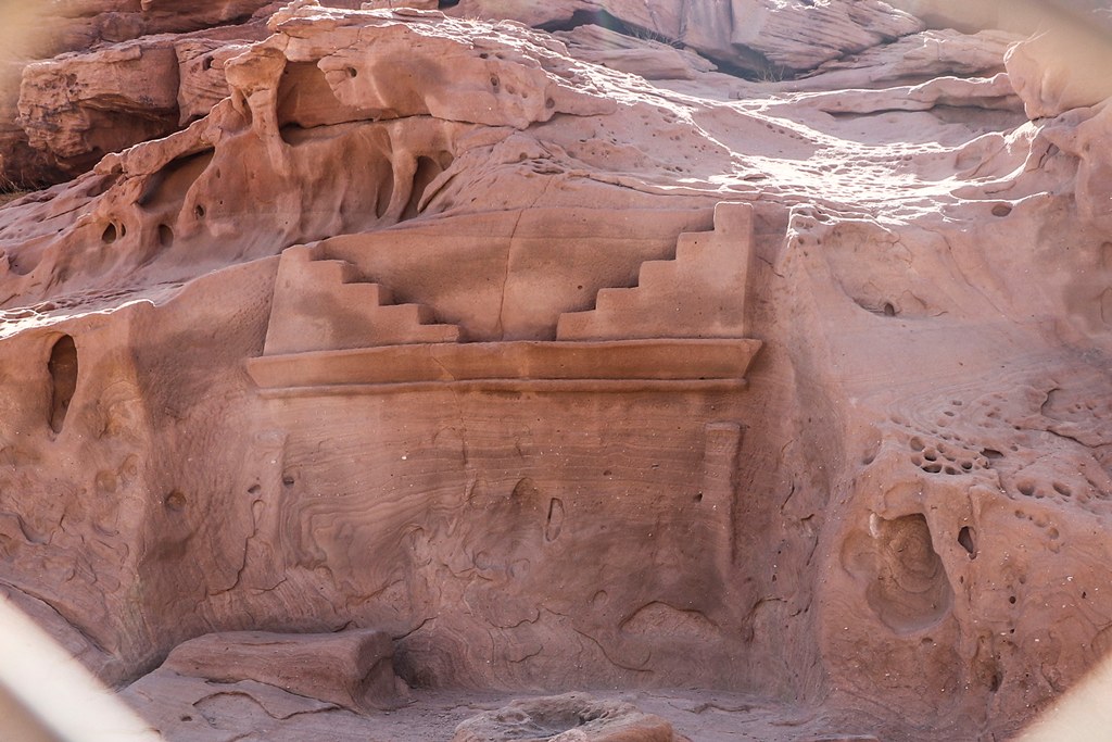
The most striking archaeological features are the Nabataean rock-cut tomb facades carved into the canyon walls. These are directly related to the more elaborate tombs at Hegra in AlUla, the Nabataean Kingdom’s second capital after Petra. The tombs at Wadi Disah are smaller and less ornate — some appear unfinished — but they confirm that the Nabataeans maintained a presence in this valley between roughly the 1st century BCE and the 2nd century CE.
Inscriptions
The sandstone walls bear inscriptions in multiple scripts: Nabataean, Thamudic, early Arabic Kufic and even Lihyanite and Aramaic. Petroglyphs depicting camels, ibex and human figures appear at various points along the canyon, some dating back several thousand years. These are best observed on the shaded north-facing walls where erosion has been gentlest.
Al-Disah Village
At the mouth of the wadi, the small village of Al-Disah retains remnants of older residential structures — stone walls and foundations that speak to centuries of continuous habitation. The village remains inhabited today and is the last supply point before entering the canyon.
Getting to Wadi Disah
From Tabuk
The standard approach starts in Tabuk city. Take Route 8900 southwest toward Duba on the Red Sea coast. After approximately 220 kilometres (around 2.5 hours of driving), you reach the village of Al-Disah. From the village, a graded dirt track continues roughly 10 kilometres to the main canyon entrance. The paved road from Tabuk is in good condition and any standard rental car will reach the village without difficulty.
4WD Requirement
Once past Al-Disah village, the terrain changes. Soft sand, shallow stream crossings and rocky patches make a 4WD vehicle essential for driving deeper into the canyon. If you arrive in a standard car, local drivers in open-top 4×4 trucks wait at the end of the paved road and offer canyon tours. The standard rate is around SAR 200–300 (USD 55–80) for a half-day excursion, though prices are negotiable.
From AlUla
Some travellers combine Wadi Disah with an AlUla trip. The drive from AlUla to Wadi Disah is approximately 400 kilometres (4–5 hours) via Route 375 and Route 8900. This makes for a long day drive but works well as part of a multi-day northwest Saudi road trip.
Flights to Tabuk
Tabuk Regional Airport (TUU) receives direct flights from Riyadh, Jeddah and several other Saudi cities on Saudia, flynas and flyadeal. International visitors will typically connect through Riyadh or Jeddah. Car rental is available at the airport — book a 4WD if you plan to enter the canyon independently.
Best Time to Visit
The ideal window is November to March, when daytime temperatures in the canyon range from 12 °C to 25 °C. Mornings can be cold — near freezing in December and January — so bring layers. The canyon floor is sheltered from wind, making it feel warmer than exposed desert even in winter.
March and April offer a brief wildflower season when the wadi floor erupts with colour after winter rains. Temperatures are still comfortable (18–30 °C), and the light for photography is exceptional.
May to September should be avoided. Temperatures routinely exceed 40 °C, and the risk of flash floods increases during summer thunderstorms. The canyon’s narrow sections can funnel water with terrifying speed — local authorities occasionally close access during storm warnings.
For detailed seasonal information across all regions, consult the Saudi Arabia weather guide.
Hiking in Wadi Disah
The main hiking route follows the canyon floor for approximately 7 kilometres one way (14 km round trip). The terrain is generally flat but uneven — expect river rocks, occasional wading through ankle-deep water in wetter months, and sections where the trail narrows between large boulders.
Difficulty and Duration
Most day hikers cover a portion of the canyon rather than the full length. A comfortable half-day excursion of 3–5 hours will take you deep enough to see the major sandstone formations, palm groves and at least one set of Nabataean inscriptions. The full 14 km round trip takes 6–8 hours at a relaxed pace with photography stops.
What to Bring
- Water: Minimum 3 litres per person per day. There are no shops or refill points inside the canyon. The spring water is not treated for drinking.
- Footwear: Sturdy hiking boots or trail shoes with good grip. Expect wet feet in some sections.
- Sun protection: Hat, sunscreen and sunglasses. The canyon floor reflects heat off the sandstone walls.
- Layers: Mornings can be cold November–February. A fleece or light jacket is essential.
- Navigation: Download offline maps (Google Maps or Maps.me) before leaving Tabuk. Mobile signal is unreliable inside the canyon.
- First aid kit: Basic supplies including blister treatment and any personal medication.
For more trail suggestions across the Kingdom, see our guide to the best hiking trails in Saudi Arabia.
Trail Etiquette
Wadi Disah is a protected area within the Prince Mohammed bin Salman Nature Reserve. Pack out all rubbish. Do not pick plants, disturb wildlife or touch the inscriptions and tomb facades. Camping fires should use brought-in fuel only — never cut living trees.
Camping in Wadi Disah
Camping inside the canyon is permitted and is the most immersive way to experience the landscape. Flat sandy areas between the palm groves make excellent campsites, with the canyon walls providing natural wind shelter.
Practical Camping Tips
- Water supply: Bring all drinking water from Tabuk. The village of Al-Disah has limited supplies.
- Firewood: Bring your own. Do not collect wood from the canyon — the tamarisk and palm trees are protected.
- Temperature: Desert nights drop sharply. A sleeping bag rated to 0 °C is advisable November–February.
- Wildlife: Store food securely. Foxes and feral cats are present. Check footwear for scorpions in the morning.
- Toilet facilities: There are none. Dig a cat hole at least 200 metres from any water source and 30 cm deep. Pack out toilet paper.
For a broader look at wild camping across the Kingdom, including permit requirements and equipment recommendations, see our camping in Saudi Arabia guide.
What Else to See Near Wadi Disah
Tabuk City
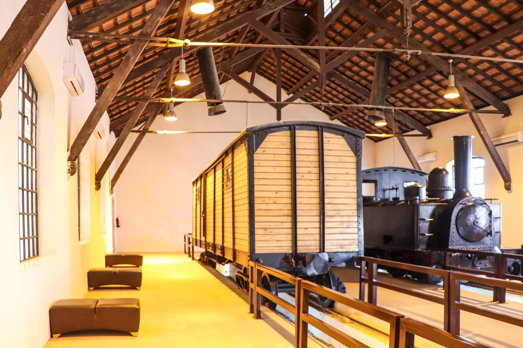
Most visitors base themselves in Tabuk for at least one night before or after the canyon. The city offers Tabuk Castle (a 3,500-year-old fortress rebuilt in the Ottoman era), the Hejaz Railway Museum (housing original rolling stock from the Damascus–Medina line) and a well-stocked old souk for last-minute supplies.
Sharma and the Red Sea Coast
The Red Sea coast at Sharma lies roughly 65 kilometres west of Al-Disah village. The turquoise waters and pristine beaches here are largely undeveloped, offering excellent snorkelling and a stark contrast to the canyon’s red rock. This stretch falls within the NEOM development zone, so expect changes in coming years.
Jabal al-Lawz
Located north of Tabuk, Jabal al-Lawz (2,549 metres) is one of Saudi Arabia’s highest peaks and occasionally receives snowfall in winter. The mountain is accessible as a day trip from Tabuk and combines well with a Wadi Disah visit for a full nature-focused itinerary.
NEOM and The Line
The broader Tabuk region is home to NEOM and The Line, Saudi Arabia’s most ambitious megaproject. While direct tourism access to NEOM’s construction zones remains limited, the surrounding landscape — particularly the coast from Gayal to Sharma — is already open to visitors.
Practical Information
Entry Requirements
International visitors need a valid Saudi tourist e-visa, obtainable online before arrival. As of early 2026, there is no separate entry fee or permit required for Wadi Disah, though this may change as the Prince Mohammed bin Salman Nature Reserve develops its tourism infrastructure.
Costs
| Item | Approximate Cost (SAR) | Approximate Cost (USD) |
|---|---|---|
| Tabuk hotel (mid-range, per night) | 250–500 | 65–135 |
| Car rental (4WD, per day) | 300–600 | 80–160 |
| Fuel (Tabuk round trip) | 120–180 | 32–48 |
| Local 4×4 guide (half day) | 200–300 | 55–80 |
| Camping | Free | Free |
| Canyon entry | Free | Free |
Safety
Flash flood warning: Wadi Disah is a natural drainage channel. During and after heavy rain — even rain falling tens of kilometres upstream — water levels can rise rapidly. Never camp in the narrowest sections of the canyon, monitor weather forecasts and retreat to high ground if you hear the sound of rushing water upstream.
- Mobile phone signal is weak to non-existent inside the canyon. Inform someone of your plans before entering.
- The nearest hospital is in Tabuk city, 2.5–3 hours away. Carry a comprehensive first aid kit.
- Summer heat can be life-threatening. Do not attempt the hike in temperatures above 40 °C without significant desert experience and abundant water supplies.
Accessibility
Wadi Disah is not wheelchair accessible. The trail surface is uneven rock and sand with stream crossings. The 4×4 ride from the village entrance takes visitors approximately 10 km into the canyon, which provides access to scenic viewpoints without requiring extensive hiking.
Planning Your Trip
Suggested 3-Day Itinerary
Day 1: Fly into Tabuk. Pick up a 4WD rental. Explore Tabuk Castle and the Hejaz Railway Museum. Stock up on water, food and fuel. Overnight in Tabuk.
Day 2: Early departure for Wadi Disah (2.5-hour drive). Spend the full day hiking the canyon — aim for at least the 7 km mark where the sandstone formations are most dramatic. Set up camp in a wide section of the wadi for the night.
Day 3: Sunrise photography and a morning walk to explore any sections you missed. Break camp by mid-morning and drive to the Red Sea coast at Sharma (65 km west) for an afternoon swim before returning to Tabuk.
Combining with Other Destinations
Wadi Disah fits naturally into a broader Saudi Arabia travel itinerary. Common combinations include:
- Tabuk + Wadi Disah + NEOM coast — 4–5 days exploring northwest Saudi Arabia
- AlUla + Wadi Disah — A Nabataean heritage arc connecting Hegra’s tombs with Disah’s canyon tombs (allow 2 days transit between)
- Full northwest loop — Jeddah → AlUla → Tabuk → Wadi Disah → Sharma coast → back to Jeddah (10–14 days, ideal for backpackers)
Explore More Saudi Arabia Travel Guides
- Saudi Arabia Hiking Guide — Every trail worth lacing up for, from Asir to Tabuk
- Tabuk Travel Guide — Gateway city to Wadi Disah, NEOM and the northwest
- Tabuk Region Guide — Desert canyons, Red Sea coast and heritage across the province
- Best Hiking Trails in Saudi Arabia — The Kingdom’s top routes ranked and mapped
- Saudi Arabia Travel Guide 2026 — The complete guide to visiting the Kingdom
- Saudi Arabia Visa Guide — Every visa type explained