
Saudi Arabia hides some of the Arabian Peninsula’s most dramatic canyon scenery deep within its arid interior — and the best way to experience it is on foot. Wadi walking, the practice of trekking through the ancient river gorges carved across the Kingdom’s mountains and plateaus, has become one of the most rewarding pursuits in adventure travel. From the towering sandstone corridors of Tabuk in the northwest to the permanently water-filled chasms of Jazan in the southwest, the Kingdom’s wadis offer terrain that ranges from gentle flat-bottomed valley strolls to narrow slot canyons where the walls press close enough to touch on both sides. This guide — part of the broader Saudi Arabia Hiking Guide — covers the best gorges and canyons for wadi walking, with everything you need to plan a safe and genuinely memorable visit.
Best Time to Visit: October to April (cooler, drier months; avoid summer heat)
Top Wadis: Wadi Disah (Tabuk), Wadi Lajab (Jazan), Wadi Tayyib Al Ism (Tabuk coast)
Visa Required: Yes — tourist e-visa, available online for most nationalities
Difficulty: Easy to hard — varies significantly by wadi; most are accessible to fit beginners
Budget: Free to enter most wadis; guided day tours from SAR 150–400 per person; 4WD hire from SAR 300/day
Avoid: Never enter a wadi floor during or after heavy rainfall upstream — flash floods can arrive without warning and are lethal
What Is a Wadi?
A wadi is an Arabic term for a valley or dry riverbed that is carved by water — typically flowing only after rainfall, though some wadis carry permanent or seasonal streams fed by groundwater or mountain springs. Across Saudi Arabia, wadis are the dominant landform in rugged terrain, cutting through granite massifs in the Hejaz Mountains, sandstone plateaus in Tabuk, and basalt fields further south. Over millions of years, episodic floods have sculpted these channels into corridors of extraordinary beauty: smooth-walled slot canyons, cathedral-like amphitheatres, palm-lined flood plains, and hanging gardens watered by seeping springs.
The practice of wadi walking — sometimes called gorge walking or canyon trekking in other parts of the world — involves following these channels on foot, typically downstream through the main canyon. The appeal is immediate: unlike summit hikes, wadi walks do not require fitness or technical skill so much as curiosity and good footwear. The terrain tells a geological story millions of years in the making, and around every bend there is something new — a spring-fed pool, a wall of fossilised rock, a sudden widening into a palm grove. For visitors exploring Saudi Arabia for the first time, wadi walking is one of the most accessible entry points into the Kingdom’s extraordinary natural landscape. For context on the broader adventure travel scene, see the Saudi Arabia Travel Guide 2026.
Wadi Disah (Wadi Qaraqir) — Saudi Arabia’s Valley of Palms
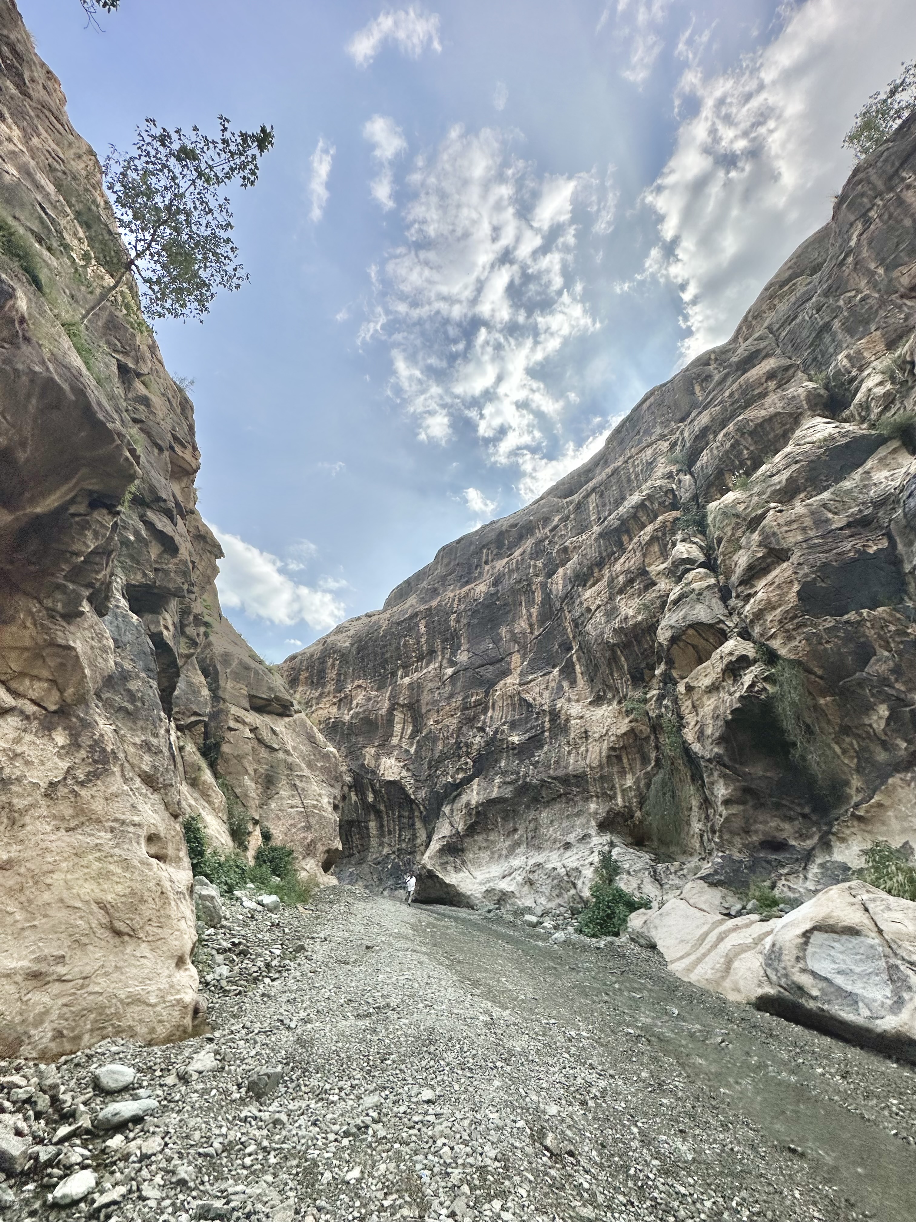
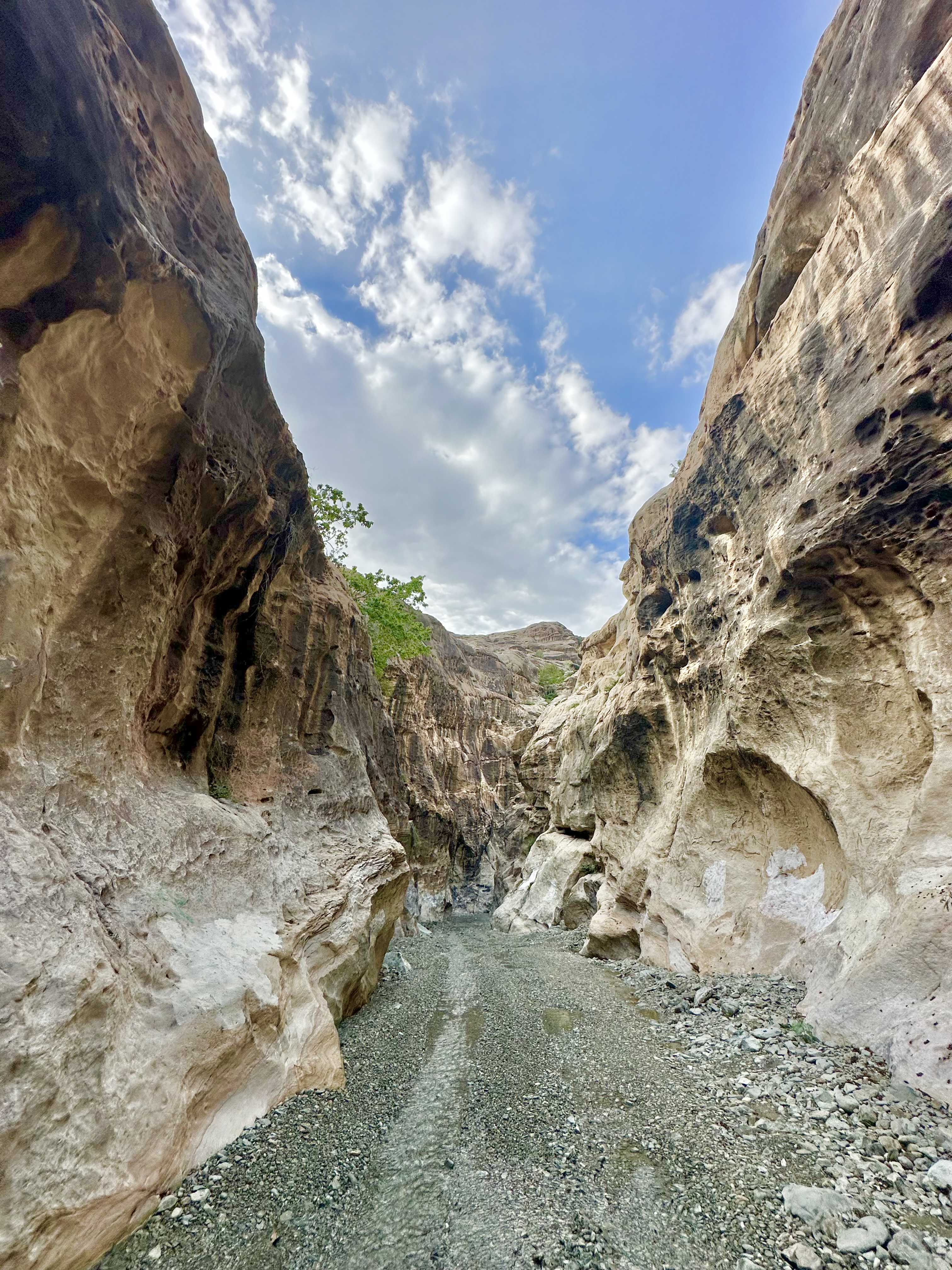
No wadi in the Kingdom commands more attention than Wadi Disah, also known as Wadi Qaraqir — a name derived from the sandstone massif of Jebel Qaraqir through which it cuts. Located in the Tabuk region of northwestern Saudi Arabia, approximately 80 kilometres south of Tabuk city and about 260 kilometres by road, this is a 15-kilometre-long canyon flanked by sandstone walls that rise to 500 metres at its deepest western section. At the canyon’s eastern entrance the cliffs already tower above 100 metres; by the time you reach the interior, you are walking through one of the most visually arresting gorges on the Arabian Peninsula.
The floor of Wadi Disah is not bare rock. A seasonal stream runs through the western portion of the canyon, and the valley floor supports a surprising abundance of life: three-metre-high reed beds, scattered palms, low shrubs, and seasonal wildflowers. Birds nest in the cliff ledges and pools form in rocky depressions during and after the wet season. Most day hikers enter from the eastern end and walk two to five hours into the canyon before turning back — covering perhaps six to eight kilometres of the full 15-kilometre length. The terrain is generally flat and non-technical: river rocks underfoot, occasional boulder scrambles, and in the wetter months some shallow wading through standing water.
A 4WD is necessary to reach the canyon entrance — the road from Al Disah village deteriorates considerably before the trailhead, though standard saloon cars sometimes make it in dry conditions. Jeep safaris from the village charge around SAR 300 per vehicle for the drive through. There are no entry fees and no formal ranger presence, though guides from the village are available and knowledgeable about canyon conditions and water levels. For more detail on the Tabuk region, including access logistics, see our dedicated guide to Wadi Disah Tabuk.
Practical note: The canyon has two entrances — eastern and western. Most hikers enter from the east (closer to Al Disah village). The western entrance is accessible from the direction of AlUla; some operators run full-day tours from AlUla covering the Wadi Qaraqir section. Allow a minimum of four hours for a meaningful visit.
Wadi Lajab — The Heaven in the Desert
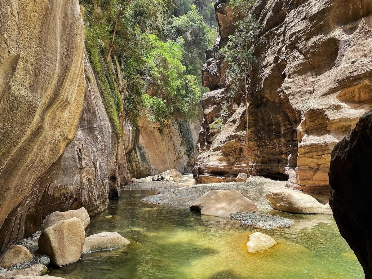
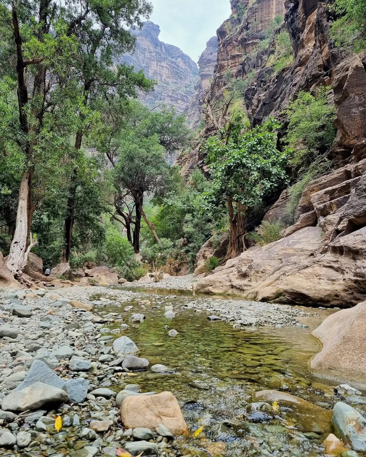
If Wadi Disah is the Kingdom’s most famous canyon, Wadi Lajab in the Jazan highlands is its most extraordinary. Located approximately 150 kilometres north of Jazan city, close to the border of Asir province, Wadi Lajab is a deep narrow gorge carved through hard metamorphic rock by centuries of water erosion. The canyon runs for approximately 11 kilometres, with two main branches totalling around six kilometres of walkable interior. What makes it genuinely unlike anything else in Saudi Arabia is the permanent water: Wadi Lajab carries a year-round stream, which means the canyon floor is never dry, the walls are draped in thick green moss and hanging ferns, and the air — even in summer — carries a cool dampness that stands in startling contrast to the surrounding desert.
The walls of Wadi Lajab are the defining feature. They range from 300 to 800 metres in height, closing in at points to create a slot canyon so narrow that sunlight reaches the floor for only a few hours each day. Waterfalls cascade from high ledges during and after rains, feeding clear pools in the canyon floor. This vegetation-draped appearance has earned the wadi its popular nickname among Saudi hikers: “Heaven in the Desert.” The Jazan Tourism Development Council has designated Wadi Lajab as an official tourist site, and the Saudi Climbing and Hiking Federation recognises it as both a hiking and rock climbing destination.
This is the one major Saudi wadi where you will definitely get wet. The stream is unavoidable — in some sections ankle-deep, in others thigh-deep when water is high. Wear trail shoes or approach shoes you don’t mind soaking, and bring a dry bag for valuables. The hike is categorised as medium to hard: the terrain is rocky and slippery, the stream crossings are frequent, and the narrow sections require squeezing through tight passages. Fit beginners can manage it with care; less mobile hikers should assess conditions on arrival. A guide is strongly recommended, as it is easy to misjudge water depth and the canyon’s geometry can be disorienting on a first visit.
Getting there: Wadi Lajab is a 2.5-hour drive from Jazan city via Highway 158 (exit at coordinates 17.591°N, 42.927°E). A 4WD is required for the final approach road. The drive from Abha in the Asir highlands takes approximately 3 hours — the Asir region is covered in detail in our Abha and the Asir Region guide.
Wadi Tayyib Al Ism — The Valley of Moses
On the northwest coast of Saudi Arabia, at a point where the Hejaz Mountains plunge into the Gulf of Aqaba near the town of Maqna, lies one of the most historically charged canyons in the Kingdom. Wadi Tayyib Al Ism — translated variously as the Valley of Moses or the Valley of the Good Name — is a granite gorge that carries one of the few permanent water flows in the entire NEOM development zone. The canyon terminates at a small beach on the Gulf of Aqaba, its granite walls rising 400 metres above the shore, with the wider massif soaring to 600 metres.
The historical significance is substantial. Islamic and Arabic tradition identifies this valley as the place where Moses spent ten years in exile after fleeing Egypt, sheltered by the Madyan people. The permanent spring that feeds the stream has sustained life here for millennia, making it a waypoint on ancient trade and pilgrimage routes between Arabia and the Levant. The hike itself follows the stream upstream from the beach — the trail is essentially the watercourse, so navigation is straightforward. The lush vegetation creates an oasis-like environment with cooler temperatures than the surrounding landscape, and the tall canyon walls provide shade for much of the day.
Access to Wadi Tayyib Al Ism is currently complicated by the NEOM development zone that encompasses the wider area. Access from the sea is restricted to NEOM badge holders. Overland access from the west requires a permit from local authorities. Travellers should check current access conditions before planning a visit — the situation is expected to evolve as NEOM’s tourism infrastructure develops. This wadi is most naturally combined with a broader Tabuk itinerary; the Tabuk region also contains Wadi Disah and sits close to the AlUla and Hegra heritage sites.
Wadi Qaraqir — The AlUla Approach
For travellers based in AlUla rather than Tabuk, Wadi Disah (Wadi Qaraqir) is accessible via a full-day tour from the city — approximately three hours each way by road. Several AlUla tour operators include the canyon as an extension of the wider Hegra heritage experience, and combined Hegra–Wadi Qaraqir itineraries are increasingly popular. The canyon’s western entrance, reachable from the AlUla direction, offers a different perspective to the eastern approach: the walls here are at their most dramatic, with the full 500-metre cliff faces visible.
AlUla itself is surrounded by extraordinary canyon and rock formation landscapes that form a natural complement to dedicated wadi walks. The sandstone pillars of the Elephant Rock area, the slot canyons at the edges of the Hegra archaeological site, and the winding valley of the ancient Nabataean trade route all reward exploration on foot. See our complete Hegra AlUla guide for the full picture of what this region offers, including the UNESCO World Heritage Site at Hegra (Mada’in Salih).
Wadis of the Asir Highlands
The Asir Mountains in southwestern Saudi Arabia form the Kingdom’s most densely folded terrain — a continuous spine of peaks running parallel to the Red Sea coast, topping out at Jabal Sawda (3,133 metres), the highest point in Saudi Arabia. This mountain range is cut by dozens of wadis descending either towards the Tihama coastal plain or eastwards into the Najd interior. The gradient is steep and the geology varied, producing canyon scenery that ranges from green, terraced valleys reminiscent of Yemen to exposed basalt gorges scoured to polished smoothness.
The village of Habala — meaning “rope” in Arabic, a reference to the rope ladders that once provided the only access — sits 300 metres below the Asir escarpment in a canyon only reachable today by cable car. The surrounding valley is a window into traditional Asiri life and the extreme terrain that shaped it. Beyond Habala, the wadis feeding into the Tihama plain carry water year-round and support some of the most biodiverse canyon environments in Arabia. The Jazan highlands, where Wadi Lajab is located, are technically part of this same mountain system. For a comprehensive guide to hiking, heritage, and accommodation in this region, see the Abha and the Asir Region guide.
The Hail Region — Desert Wadis of the North
In northern Saudi Arabia, the Hail region presents a different wadi character: wider, drier, and more austere, but no less dramatic. The Aja and Salma mountains near Hail city are granite massifs interspersed with sandy valleys and wadi systems that carry flash floods during winter rains. The landscape here is rawer than the southern highlands — fewer trees, less permanent water — but the geological formations are spectacular, with exposed granite walls rising from sand plains and ancient rock art recorded in the valley floors. Our Hail Region guide covers the best access routes and points of interest across these northern wadis. Hail also makes a logical stop for overlanders combining wadi exploration with Saudi Arabia rock climbing, as the granite walls provide excellent technical routes alongside the walking terrain.
Flash Flood Safety — The Non-Negotiable Rule
Flash floods are the single greatest hazard in Saudi wadi walking, and they kill people every year. The key point to understand is that a wadi flood does not require rain at your location — a storm 30, 50, or even 100 kilometres away, high in the mountains, can send a wall of water through a canyon with zero warning at the lower end. The water arrives fast, often mixed with debris, boulders, and sediment, and it fills narrow canyons to the brim within minutes.
Flash flood rules — always follow these:
- Check weather forecasts for the entire upstream catchment area — not just your location — before entering any wadi
- Never camp in a wadi floor, even if the sky is clear and the forecast looks good
- If you hear a rumbling sound or notice water levels rising, move immediately to high ground — do not wait to assess the situation
- Watch for warning signs: muddy water where there was none, floating debris, sudden change in the sound of the stream
- November through March is the primary flash flood risk season, coinciding with the wadi walking season — be especially vigilant after any rainfall in the mountains
- Tell someone your intended route and expected return time before entering a remote wadi
The Jazan and Asir highlands are particularly prone to convective rainfall events — intense, localised thunderstorms that can deposit 50–100mm of rain in a short period. Wadi Lajab’s permanent stream means that even in dry periods the canyon floor is wet and the water level can rise quickly. Wadi Disah’s more open floor and sandier terrain makes flood debris less acute, but a major storm event will still close the canyon. When in doubt, do not enter.
Gear and Practical Preparation
Footwear
The right footwear makes a significant difference across all Saudi wadi terrain. For dry wadis like Wadi Disah, a mid-cut hiking boot with a Vibram-type rubber sole is the standard recommendation — it provides grip on smooth wet rock, protects ankles on uneven riverbed terrain, and keeps sand and small rocks out. Pair with moisture-wicking wool or synthetic hiking socks to minimise blister risk on long days.
For wet wadis like Wadi Lajab, the calculation changes. Trail running shoes or approach shoes in a quick-drying synthetic material are better suited to sustained stream walking than leather boots, which become waterlogged and heavy. Some hikers use dedicated water shoes or sandals with ankle support for wet canyon sections. Whatever you choose, avoid smooth-soled footwear — the rock surfaces in these wadis are slippery when wet.
Water and Nutrition
Carry more water than you think you need. In cooler months (October–April), a minimum of 3 litres per person for a full-day wadi walk is standard. In warmer months, increase this significantly. Despite the presence of running water in Wadi Lajab and Wadi Tayyib Al Ism, drinking untreated wadi water is not advisable — the streams pass through grazing areas and may carry bacterial contamination. Water purification tablets or a filter bottle are worth carrying for extended backcountry trips.
Clothing and Cultural Considerations
Saudi Arabia’s cultural norms apply even in remote outdoor settings. Women should wear loose-fitting long trousers and a long-sleeved top as a minimum, with a headscarf available for encounters with local communities. Men should avoid wearing shorts in populated areas near the trailheads. The practical benefit of loose, lightweight long clothing also happens to coincide with the cultural requirements: full coverage protects against sun exposure and scratches from rocky terrain.
Navigation and Communication
Most Saudi wadi hikes do not require navigation skills — the canyon walls do the work. However, in wider wadis with multiple branches (such as Wadi Disah), it is possible to take the wrong fork and lose considerable time. Download offline maps via Maps.me or download the relevant 1:50,000 topographic tiles before departing — Saudi Arabia’s cell coverage deteriorates sharply once you are inside a deep canyon, and Google Maps satellite imagery does not always differentiate between main channel and tributary. A hired local guide from the nearest village is often the most reliable navigation solution.
Best Time of Year
The walking season runs October through April, coinciding with Saudi Arabia’s cooler months. This is also the wetter period — most wadis see their maximum water flow, and the flash flood risk is highest from November to March. The sweet spot is October–November and March–April, when temperatures are moderate, vegetation is at its most vibrant, and the weather is generally settled. December through February can see cold nights in the highlands (temperatures dropping to near freezing at altitude in the Asir) but mild daytime temperatures ideal for walking.
Summer (May–September) is feasible only in higher elevation wadis in the Asir and Jazan highlands, where temperatures are somewhat moderated by altitude and cloud cover. Wadi Lajab’s permanent shade and year-round stream make it more accessible in summer than most, but daytime temperatures in the canyon can still exceed 35°C. Wadi Disah in Tabuk is effectively inaccessible in summer without serious heat management — the canyon provides minimal shade and temperatures routinely exceed 40°C.
Permits and Access
Most Saudi wadi hikes require no formal permit. Open desert and mountain terrain in Saudi Arabia is generally accessible to visitors with a tourist visa — check the Saudi Arabia visa guide for the full breakdown of visa types and requirements. The main exceptions are designated nature reserves and protected areas managed by the National Center for Vegetation Cover, which require a digital permit obtained through the centre’s website.
Wadi Tayyib Al Ism, as noted, is currently subject to NEOM zone access restrictions and requires a separate permit process. Some national parks within the Asir and Hejaz regions also require permits. The Saudi Climbing and Hiking Federation (climbing.sa) maintains an updated list of licensed guides and can advise on current permit requirements for specific locations. For most visitors, however — particularly those visiting Wadi Disah and Wadi Lajab — open access with no permit is the norm.
Getting Around — Transport Logistics
A 4WD vehicle is essential for reaching the trailhead of most significant Saudi wadis. Public transport does not serve remote canyon areas. The options are: hire a 4WD in major cities (available from all major rental companies at Tabuk, Abha, Jazan, and AlUla airports); join an organised day tour from the nearest city; or hire a local driver–guide from the village nearest the canyon entrance. The latter option is typically the most economical and the most informative — local guides know the water conditions, the best entry points, and the correct route through complex canyon systems.
Tabuk is the gateway city for Wadi Disah and Wadi Tayyib Al Ism — allow two to three hours’ drive from Tabuk to either trailhead. Jazan or Abha is the base for Wadi Lajab (approximately 2.5–3 hours from either city). AlUla serves as an alternative entry point for the western Wadi Qaraqir section.
Explore More Saudi Arabia Travel Guides
- Saudi Arabia Hiking Guide — Best trails and trekking in the Kingdom
- Wadi Disah Tabuk — Saudi Arabia’s Grand Canyon
- Abha and the Asir Region — Saudi Arabia’s mountain escape
- Hegra AlUla — Desert canyons and Nabataean tombs
- Saudi Arabia Travel Guide 2026 — The complete guide to visiting the Kingdom
- Saudi Arabia Visa Guide — Every visa type explained