Best Time: October–March (mild days, cool nights; temperatures 15–25°C)
Top Attractions: Wadi Disah canyon, Tabuk Castle, Haql beach and the Georgios G shipwreck, Jabal Al-Lawz, Al-Bad’ and Maghair Shuaib, NEOM Bay, Hisma Desert
Visa Required: Yes — tourist e-visa, available online in minutes
Getting There: Fly into Tabuk Airport (TUU) — direct flights on Saudia, Flynas and flyadeal from Riyadh, Jeddah and Dammam; international connections via those hubs
Budget: SAR 300–600 per day (mid-range; budget travellers SAR 150–250, luxury SAR 1,000+)
Avoid: June–September — daytime highs reach 42–45°C; Wadi Disah can flood in winter rain
Northwest Saudi Arabia is the kingdom’s most geographically dramatic corner, and at its heart sits Tabuk — a region that packs desert canyons, Red Sea shorelines, ancient pilgrimage forts, and the most ambitious construction project on earth into a single province the size of France. This is the full guide to the Tabuk travel region, from its sand-blasted highlands to the coral-fringed Gulf of Aqaba. If you have been wondering whether northwest Saudi Arabia is worth the journey, the answer is an unequivocal yes — and 2026 is an excellent year to make it.
For context on travelling across the kingdom before you arrive, consult the Saudi Arabia Travel Guide 2026, which covers entry requirements, cultural norms, transport and money for the country as a whole. For visa specifics, the Saudi Arabia Visa Guide explains the tourist e-visa, the Umrah visa, and every other category in detail.
Understanding the Tabuk Region
Tabuk Province covers approximately 118,000 square kilometres of northwestern Saudi Arabia, bordered by Jordan to the north, the Gulf of Aqaba and the Red Sea to the west, and the vast inland desert of the Hejaz to the east and south. The province’s western fringe is defined by more than 500 kilometres of coastline — the longest Red Sea shoreline of any Saudi province — running from the Jordanian border at Haql in the north all the way south past Sharma, Maqna, Umluj and Al-Wajh.
The city of Tabuk itself sits at an elevation of roughly 770 metres above sea level on a high plateau, which explains why temperatures here are noticeably cooler than coastal cities and significantly more bearable than Riyadh or the Eastern Province in winter. The plateau descends sharply to the west through dramatic sandstone escarpments — the geological backdrop for Wadi Disah and the Hisma Desert — before levelling out into the coastal Tihama plain and eventually reaching the sea.
Historically, Tabuk sat astride one of the most important overland routes in the Islamic world: the Darb al-Hijaz, the pilgrimage road connecting Egypt and the Levant with Makkah and Madinah. The Prophet Muhammad himself led an expedition to Tabuk in 630 CE, and Ottoman sultans later invested heavily in fortified rest stops along the route. That layered history — Nabataean, early Islamic, Ottoman — runs through nearly every heritage site in the region.
Tabuk City: Gateway and Base
With a population of around 600,000, Tabuk is the largest city in northwestern Saudi Arabia and the natural base for exploring the province. It is a modern, functional city rather than a showpiece destination, but it has its own quiet pleasures: well-kept parks, a reasonable dining scene along King Fahd Road, and a handful of heritage sites within the city limits that reward an afternoon’s exploration.
Tabuk Castle
Tabuk Castle — Qal’at Tabuk in Arabic — is the city’s most visited heritage attraction and a logical first stop. The existing structure dates primarily to 1064 AH (approximately 1653 CE), when the Ottomans rebuilt an earlier fort to serve travellers on the Darb al-Hijaz pilgrimage road. The castle’s thick mud-brick walls enclose a central courtyard with a mosque, guardrooms, and — critically for any desert fort — a perennial spring. That spring, known as Ain al-Sukkar, is mentioned in early Islamic sources as a watering point on the Prophet Muhammad’s Tabuk expedition in 9 AH/630 CE, which gives the site religious as well as historical significance.
The castle was restored in the 1990s and opened to visitors free of charge. Inside, the rooms have been fitted with mannequins and display cases illustrating daily life on the pilgrimage route: ceramic water vessels, saddle equipment, weapons, and period documents. The two towers flanking the main gate offer views over the surrounding streets. Allow 45 minutes to an hour. The castle is located in the old city quarter near Al-Nuzha Park, roughly ten minutes by taxi from the main hotel district.
Al-Shallal Theme Park and Al-Nuzha Park
Families travelling with children will find Al-Shallal Theme Park a useful half-day option on rest days. Al-Nuzha Park, adjacent to the castle, is a popular local green space and an ideal spot to observe everyday Tabuki life, particularly on Thursday evenings when families gather after sunset prayer.
Practical Tabuk City Notes
The city’s hotel supply is adequate rather than exceptional. International chains represented include Intercontinental (on the airport road), Marriott Courtyard, and several Rotana properties. Budget options cluster near the commercial centre on King Fahd Road. Car hire is available at the airport and in the city — essential for reaching Wadi Disah, the coast, and other provincial sites. Taxis and the Careem ride-sharing app operate within the city.
Tabuk airport (IATA: TUU) sits roughly five kilometres northwest of the city centre. Direct domestic routes connect it to Riyadh (King Khalid International), Jeddah (King Abdulaziz International) and Dammam (King Fahd International). Saudia, Flynas and flyadeal all operate these routes. International visitors typically connect through Riyadh or Jeddah. In 2026, the airport is undergoing capacity expansion in anticipation of increased NEOM-related traffic.
Wadi Disah: Saudi Arabia’s Grand Canyon
If the Tabuk region has one single attraction that demands a dedicated journey — from Riyadh, from abroad, from anywhere — it is Wadi Disah. Known also as Wadi Qaraqir, and colloquially as the Valley of Palm Trees, this fifteen-kilometre canyon cuts through the Jebel Qaraqir sandstone massif approximately 200 kilometres south of Tabuk city. For the full detailed guide, see Wadi Disah Tabuk: Saudi Arabia’s Grand Canyon.
The statistics are arresting: sandstone cliffs rise up to 400 metres on either side of the canyon floor. Underground springs feed year-round pools and support a ribbon of date palms, wild grasses, and oleander — a startling green strip running through the rust-red rock. Nabataean rock-cut tombs are carved into the cliff faces above the valley floor, their facades weathered but recognisable. The canyon’s floor is traversed on foot or, in some sections, by 4WD along a sandy track.
Wadi Disah is not yet a heavily managed tourist site. There is no admission fee, no ticketing system, and limited infrastructure. A handful of simple camps operate during the cooler months, offering basic accommodation and guided jeep tours into the canyon. Most visitors drive in from Tabuk city, camp overnight, and return the following day — a rhythm that suits the place well. The road from Tabuk heads south on Highway 15 toward Al-Ula before branching west at Shahar; the final approach involves a descent through increasingly dramatic escarpment terrain. A high-clearance vehicle is recommended but not mandatory for reaching the canyon entrance; a 4WD becomes essential if you want to explore deeper inside.
For those interested in broader hiking possibilities across Saudi Arabia’s northwest, the Saudi Wadi Walks guide catalogues routes across multiple provinces.
The Red Sea Coast: Haql, Maqna, and the Gulf of Aqaba
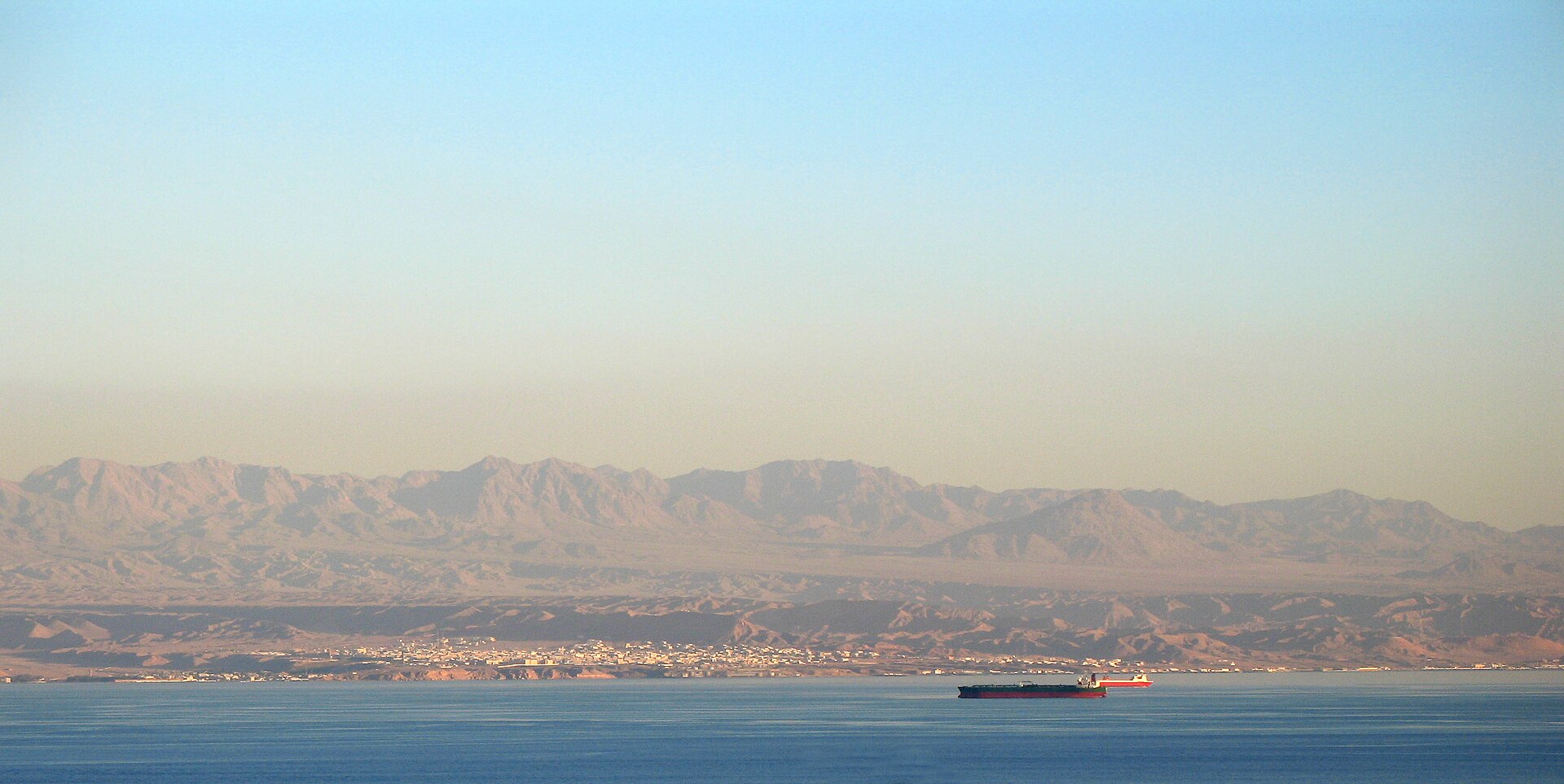
Tabuk Province holds more than 500 kilometres of Red Sea coastline, and the northern section — the Gulf of Aqaba shoreline running from Haql down to Sharma — is arguably the most spectacular. The gulf’s enclosed geometry means calmer, cleaner water than the open Red Sea, exceptional visibility for diving and snorkelling, and a string of beaches that, even now, see relatively few visitors compared to their objective quality.
Haql
Haql is the northernmost coastal town in Saudi Arabia, sitting just south of the Jordanian border. Its beach is a long arc of white sand backed by tamarisk scrub, with water that shades from pale turquoise in the shallows to deep cobalt offshore. The town itself is small — a few thousand residents, a handful of restaurants, basic guesthouses — but its reputation among Saudi weekenders is well established.
The principal draw for divers and snorkellers is the Georgios G: a Greek-registered cargo vessel that ran aground on the coral reef in 1978 and now sits half-submerged at the edge of the beach, close enough that you can wade out to it at low tide. The wreck has been colonised by coral and supports a dense fish community — moray eels, lionfish, barracuda, sand tiger sharks, and schools of surgeonfish. Local dive operators offer guided dives around the hull. Non-divers can observe the upper structures clearly from the surface. The Georgios G is genuinely one of the most accessible shipwrecks in the Middle East.
Haql is approximately 330 kilometres northwest of Tabuk city by road — roughly four hours — or accessible as a day trip from the Jordanian side via the Durra border crossing, which opened to Saudi tourism in recent years.
Maqna and Sharma
South of Haql, the coast road winds through a series of small fishing settlements before reaching Maqna, a historically significant bay where the Ottomans once maintained a garrison protecting the pilgrimage sea route. The bay is sheltered and shallow, popular with local families for camping. The water is extraordinarily clear — the kind of clarity where coral heads are visible from ten metres above the surface. A few basic rest areas and camping spots line the shoreline.
Sharma, further south, is where the NEOM development zone meets the coast. Access to Sharma Bay is currently restricted while NEOM construction proceeds, but the coastal road in the approaches remains open. As NEOM phases come online through 2026 and beyond, Sharma is expected to become one of the region’s primary visitor entry points. The adjacent NEOM Nature Reserve, which protects the inland Hisma terrain, is being developed for eco-tourism with guided safari experiences.
The Red Sea Destination (Amaala and Red Sea Project)
South of Sharma, the coastline transitions into the zone covered by The Red Sea Project — a separate but related development that encompasses more than 90 offshore islands and 200 kilometres of coast between Umluj and Al-Wajh. The first resort hotels under this project opened in late 2023, with a phased rollout continuing through 2026. The development targets ultra-luxury travellers and positions itself as a regenerative tourism destination, with no single-use plastics, a renewable-energy grid, and strict limits on the number of visitor permits issued. Booking in advance through official channels is essential.
Jabal Al-Lawz: The Mountain of Almonds

Rising to 2,580 metres near the Jordanian border, Jabal Al-Lawz — the Mountain of Almonds — is one of the highest peaks in the Arabian Peninsula and one of the few places in Saudi Arabia that reliably receives snowfall. In December and January, the upper slopes are often dusted white, a sight that draws overnight convoys of Saudi families from across the kingdom, many of whom have never seen snow at close range.
The mountain’s name comes from the wild almond trees that grow on its middle slopes. Its granite summit is accessible by 4WD on a rough track that climbs from the village of Sharma al-Jabal, roughly 30 kilometres south of the town of Bid’. The final approach on foot takes another two to three hours in moderate terrain. The summit plateau offers views across the Hisma Desert to the east and the Gulf of Aqaba coastline to the west on clear days.
Jabal Al-Lawz occupies an unusual place in the popular imagination beyond Saudi Arabia. Since the 1980s, a number of researchers — most notably American adventurers Bob Cornuke and Larry Williams — have argued that the mountain is the true location of the biblical Mount Sinai, pointing to the blackened granite summit (which they interpret as evidence of divine fire), the large plain at its base (which they associate with the Israelite encampment), and the nearby spring at Al-Bad’. The Saudi government has not endorsed this interpretation, and mainstream biblical scholarship remains sceptical, but the theory has given the mountain an international profile that draws a particular category of historically-minded visitor.
Whatever your view on the biblical question, the mountain is a superb hiking and photography destination. The best ascent season is October through March. In summer the heat at altitude is less extreme than on the coast, but temperatures still reach the mid-thirties by midday.
Al-Bad’ (Al-Bid’) and the Land of Midian
One of the least-visited and most historically resonant sites in the Tabuk region is Al-Bad’, a small town on the coast roughly 225 kilometres west of Tabuk city. Islamic tradition identifies this location with the ancient land of Midian — the territory where, according to both the Quran and the Bible, the Prophet Moses (Musa) lived in exile after departing Egypt and where he encountered Shuaib (Jethro), whose daughter he later married. The spot where Moses is said to have watered the flocks of Shuaib’s daughters is commemorated by a well on the edge of town known as Bir al-Musa, still used today.
Two kilometres south of the modern town, a cluster of rock-cut tombs known as Maghair Shuaib — literally the Caves of Shuaib — are carved into sandstone outcrops in a style closely related to the Nabataean tombs of Hegra (Mada’in Saleh) and Petra. They are dated to the first century CE. The facades are simpler than Petra’s great monuments, but the setting is extraordinary: salmon-coloured sandstone cliffs catching the afternoon light, the tombs arranged in tiers above a gravel wadi, with silence broken only by the occasional call of a desert bird.
Al-Bad’ is most naturally visited in combination with the coastal drive through Haql and Maqna. There is limited accommodation in town; most visitors either camp in the area or base themselves in Tabuk city and make the journey as an overnight trip.
The Nabataean civilisation that carved the tombs at Maghair Shuaib also built the city of Hegra — known today as Mada’in Saleh — some 500 kilometres to the south. Between these two sites, the Nabataean trade network once stretched from the Hejaz to Syria, Arabia Felix to the Mediterranean. The Tabuk stretch of that network is far less visited than Hegra and correspondingly more evocative for it.
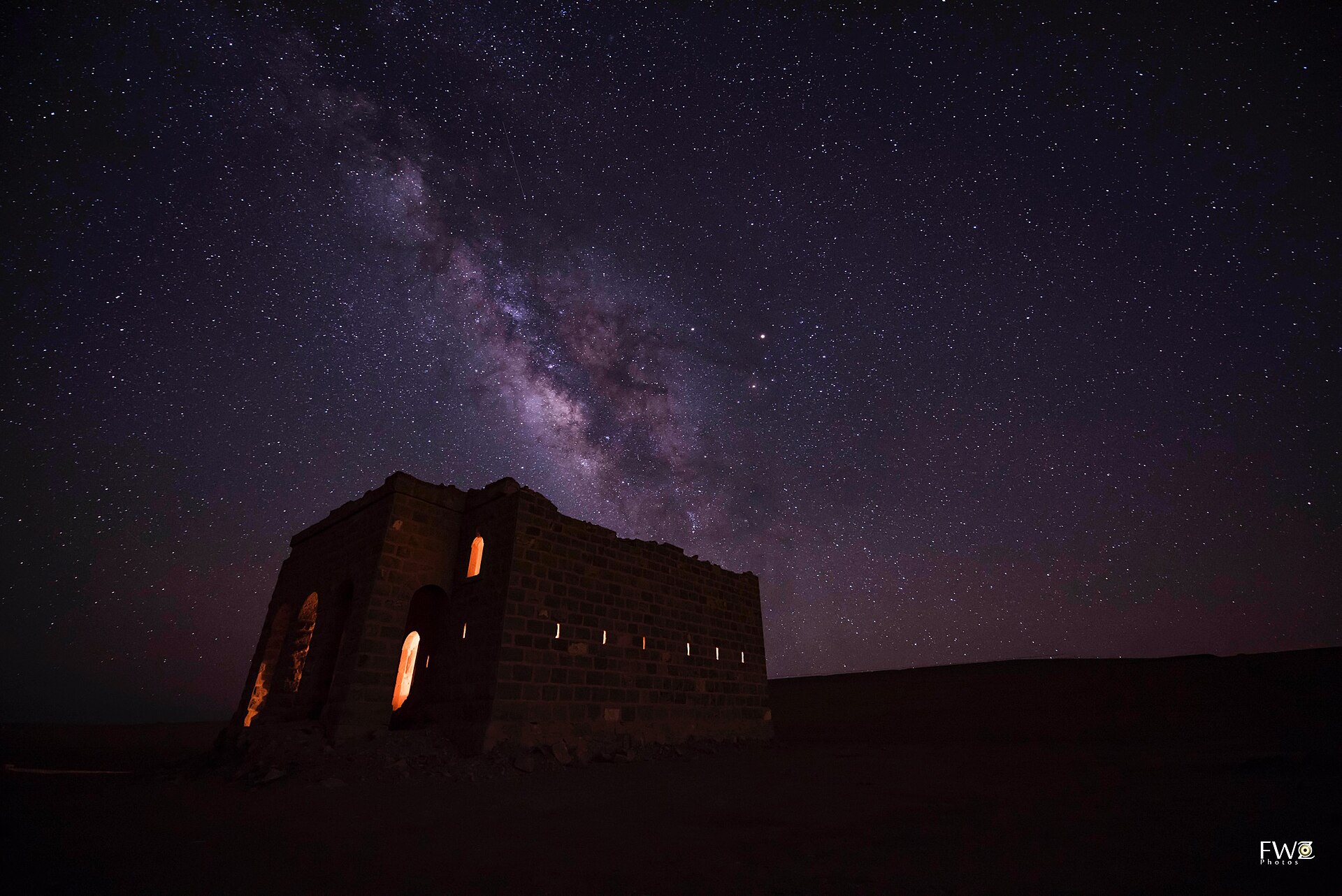
The Hisma Desert: Saudi Arabia’s Wadi Rum
East and south of the Red Sea coast, the land rises through the Tabuk escarpment and levels out into the Hisma — a high desert plateau of crimson sand dunes, weathered granite inselbergs, and extraordinary sandstone pillars. The Hisma is the geological twin of Wadi Rum immediately across the border in Jordan, shaped by the same tectonic forces and erosion processes over hundreds of millions of years. Where Wadi Rum has been comprehensively developed for tourism, the Hisma remains largely raw and undiscovered.
The most accessible section of the Hisma is the area south of Tabuk city along the route toward Wadi Disah, where the terrain transitions visibly from flat agricultural plateau to deeply eroded canyon country. The NEOM development incorporates a large section of the northern Hisma, where the Nature Reserve will eventually offer guided vehicle-based safaris, stargazing experiences, and guided treks. The exceptional clarity of the night sky above the Hisma — away from coastal settlement and the city’s light pollution — makes it one of the finest stargazing locations in the Middle East.
Independent travellers can experience the Hisma terrain without entering the NEOM zone, particularly in the areas around Wadi Disah and the Jebel Qaraqir massif. Camping in the open desert is legal with appropriate permissions and deeply rewarding: the combination of sandstone formations, cooling temperatures after sunset, and near-total silence is difficult to replicate anywhere else in the kingdom.
NEOM and Tabuk’s Future as a Tourism Destination
No discussion of the Tabuk region in 2026 can avoid NEOM, the $500 billion giga-project occupying a 26,500-square-kilometre zone in the province’s northwest corner. The full detail is covered in the dedicated NEOM Visitor Guide and the The Line Explainer, but the key practical points for Tabuk travellers are these.
NEOM Bay — the coastal zone around Neom Bay airport — is the most accessible part of the project in 2026. The airport (IATA: NUM) has received limited commercial flights, primarily charter operations serving NEOM workers, but commercial access is expanding. The coastal settlements in NEOM Bay zone are being developed as the region’s first visitor-facing hospitality nodes. Road access from Tabuk city is approximately 150 kilometres on a newly widened highway.
The Line — NEOM’s signature linear city — remains under construction. Significant visible infrastructure now exists in the Hisma terrain, including the mountain cuts and foundation works, but the structure is not open to visitors. Drone photography of NEOM construction zones is prohibited and actively enforced. The boundary of the NEOM zone is marked, and access beyond it requires a NEOM-issued permit.
Sindalah Island, NEOM’s first completed element, opened as a luxury marina and yacht destination in 2024. It is accessible by boat from Haql or, once fully operational, by ferry from NEOM Bay. The island caters specifically to the superyacht market, with moorings, F&B outlets, and beach facilities.
Tayma, the ancient oasis city 250 kilometres southeast of Tabuk, falls within the broader travel region and makes a compelling addition to any Tabuk itinerary. The full guide to Tayma Oasis covers its remarkable archaeological heritage, including the Tayma Stone — one of the most important Aramaic inscriptions ever discovered — and the ruins of the sixth-century BC Babylonian governor’s palace.
Itinerary Suggestions
Three Days: The Essential Northwest Circuit
Day 1: Arrive Tabuk, check in, visit Tabuk Castle in the afternoon. Evening walk along King Fahd Road, dinner at a local restaurant in the commercial centre.
Day 2: Early departure south toward Wadi Disah. Arrive mid-morning, spend the day exploring the canyon on foot — the lower section near the canyon entrance is accessible without a guide; the upper section rewards hiring a local jeep operator. Camp inside or near the canyon overnight. Sunrise from the canyon rim is exceptional.
Day 3: Return to Tabuk via Shahar and the plateau road. Stop at viewpoints over the escarpment. Afternoon flight out.
Five Days: Canyons, Coast, and Heritage
Days 1–2: As above (Tabuk city and Wadi Disah).
Day 3: Drive northwest from Wadi Disah toward the coast, stopping at Al-Bad’ to visit Maghair Shuaib in the afternoon. Continue to Maqna Bay for the night (camping or basic guesthouse).
Day 4: North along the coast road to Haql. Snorkelling around the Georgios G wreck in the morning. Lunch in Haql, then drive back southeast to Tabuk city, arriving evening.
Day 5: Morning visit to Jabal Al-Lawz (in winter/spring) or Tayma Oasis. Return to Tabuk for a late flight.
Seven Days: The Full Province
Add Tayma Oasis as a separate day trip east of Tabuk (see Tayma Oasis guide). Consider a night in the Hisma Desert east of Wadi Disah. In season (October–March), add the Jabal Al-Lawz ascent as a dawn start from Tabuk city or from a camp at the mountain base.
When to Visit Tabuk Region
The optimal travel window is October through March, when daytime temperatures in Tabuk city range from 15°C to 25°C, nights can drop to 4°C or below (relevant for camping), and the air is dry and crystal-clear. Wadi Disah is at its most vivid in this period, with the springs running, the palms green, and the light at a low enough angle to saturate the sandstone colours.
December and January are peak season for Jabal Al-Lawz snow tourism — Saudi families drive from Riyadh and Jeddah specifically for this. The mountain roads can become congested on weekends in this period; plan for a weekday visit if possible.
April and May are a shoulder period: warm enough to be comfortable on the coast, but increasingly hot inland by midday. June through September should be avoided for most outdoor activities — inland temperatures reach 42–45°C, and the combination of heat and low humidity makes extended outdoor exposure genuinely hazardous without proper preparation and shade.
The Red Sea coast enjoys slightly moderated temperatures compared to the inland plateau year-round, and serious divers consider the spring months (March–May) excellent for visibility and marine activity.
Getting Around Tabuk Region
A private vehicle — ideally a high-clearance SUV — is essentially mandatory for exploring the province independently. Distances are large: Wadi Disah is 200 kilometres from Tabuk city, Haql is 330 kilometres, and Al-Bad’ is 225 kilometres. Public transport between these destinations is either absent or unreliable. Car hire at Tabuk Airport is available through Hertz, Budget, and local operators; book in advance during peak season (November–February) as supply is limited.
Guided tours are an increasingly popular option. Saudi-based operators including Desert Journey Arabia and Awn Travel offer multi-day circuits covering Wadi Disah, the coast, and Jabal Al-Lawz. International operators — particularly UK-based adventure travel companies — have begun including Tabuk in broader Saudi itineraries as part of the kingdom’s tourism opening.
Petrol stations are widely spaced outside Tabuk city. Fill up before leaving on any desert or mountain route. Mobile coverage is reasonable along the main highways but absent in many valley and canyon settings — download offline maps (Maps.me and Google Maps both have reasonable Saudi coverage) and share your itinerary with someone before heading into remote terrain.
Practical Travel Notes
Accommodation
Tabuk city has the widest range: international hotels (Intercontinental, Marriott Courtyard, Rotana), local mid-range options (SAR 250–500 per night), and budget properties near the commercial centre (SAR 100–180). Outside the city, accommodation options are limited to desert camps (basic, seasonal, excellent value), basic guesthouses in coastal towns like Haql, and wild camping — legal with a permit in most non-restricted areas.
Food and Drink
Tabuk city has a wide range of restaurants: shawarma shops, traditional Saudi kabsa restaurants, Egyptian and Yemeni eateries, and several international fast-food outlets. Al-Mazraq and the commercial district around Prince Sultan Street are the main dining areas. Outside the city, options are extremely limited — stock provisions (food, water, fuel) before leaving on any multi-day route. The Red Sea coast around Haql and Maqna has a few small restaurants serving fresh fish; ask locally for the best options as they change seasonally.
Safety and Regulations
The Tabuk region is considered safe for tourists. That said, standard desert-travel precautions apply: always carry significantly more water than you think you need (a minimum of three litres per person per day when walking in the sun), inform someone of your route, and do not enter NEOM restricted zones without the appropriate permit. The NEOM boundary is signposted and the prohibition on unauthorised entry is taken seriously.
Photography of military installations — which exist in the Tabuk region given its proximity to the Jordanian and Israeli borders — is prohibited. This is not specifically targeted at tourists but is enforced uniformly. At civilian heritage sites, photography is freely permitted.
Currency and Payments
The Saudi Riyal (SAR) is the currency. ATMs are available throughout Tabuk city and at petrol stations on main highways. Card payment is accepted at hotels and major supermarkets. In remote towns, coastal settlements, and camp operators, cash is often the only option. Carry sufficient riyals before leaving the city.
Explore More Saudi Arabia Travel Guides
- Tabuk Travel Guide 2026 — Complete Tabuk city guide
- Wadi Disah Tabuk — Saudi Arabia’s Grand Canyon
- NEOM Visitor Guide — What tourists can actually see
- Tayma Oasis — Ancient oasis city in northwest Saudi
- Saudi Arabia Travel Guide 2026 — Complete Kingdom guide
- Saudi Arabia Visa Guide — Every visa type explained