
The Taif to Abha highland loop is the most spectacular road trip in Saudi Arabia. Spanning roughly 600 kilometres along the spine of the Sarawat Mountains, this drive connects the rose gardens of Taif with the misty peaks of Asir through a corridor of ancient stone villages, juniper forests, and terraced hillsides that most visitors to the Kingdom never see. Whether you complete it as part of a wider Abha and Asir travel itinerary or treat it as a standalone adventure, this is the route that changes how people think about Saudi Arabia travel. The road climbs from 1,879 metres at Taif to over 3,000 metres at Jabal Sawda near Abha, passing through the Al Baha highlands and the fog-wrapped towns of Al Namas and Tanomah along the way.
Best Time to Visit: October to March (cooler temperatures, clear skies, minimal fog)
Getting There: Fly into Taif Regional Airport (TIF) or drive from Jeddah (1.5 hours); return from Abha Regional Airport (AHB)
Visa Required: Yes — tourist e-visa
Budget: $80–$150/day (car rental, fuel, hotels, meals)
Must-See: Dhee Ayn marble village, Raghadan Forest Park, Habala hanging village
Avoid: Driving at night on mountain switchbacks; summer fog between June and August above 2,000 m
Why Drive the Taif–Abha Highland Loop
Saudi Arabia has more than 2.5 million square kilometres of territory, and most travellers see only the flat parts. The Sarawat Mountains running parallel to the Red Sea coast form a continuous highland chain that reaches over 3,000 metres in the Asir region, producing a climate and landscape radically different from the desert interior. The Taif–Abha route follows Highway 15 (also known as the Hejaz Highway) along this escarpment, delivering a succession of overlooks, heritage villages, and mountain forests that rival anything in the Atlas, the Ethiopian Highlands, or the Omani Jebel Akhdar.
This is not an extreme off-road expedition. Highway 15 is fully paved and well-maintained throughout, with fuel stations in every major town. A standard rental sedan handles it comfortably. What makes the drive special is the density of things worth stopping for: a UNESCO-tentative marble village, a 25-tunnel mountain road, juniper forests older than the Kingdom itself, and a cliff settlement reachable only by cable car.
Route Overview and Driving Segments
The full one-way drive from Taif to Abha covers approximately 600 km and takes 7–8 hours of pure driving time. Most travellers spread it across 3–4 days to allow proper stops. Here is the route broken into logical segments:
| Segment | Distance | Driving Time | Elevation |
|---|---|---|---|
| Taif to Al Baha | ~280 km | 3–3.5 hours | 1,879 m → 1,900 m |
| Al Baha to Al Namas | ~170 km | 2–2.5 hours | 1,900 m → 2,500 m |
| Al Namas to Tanomah | ~60 km | 45 min–1 hour | 2,500 m → 2,400 m |
| Tanomah to Abha | ~90 km | 1–1.5 hours | 2,400 m → 2,200 m |
Tip: If you are renting a car in Saudi Arabia, pick up in Taif and drop off in Abha (or vice versa). One-way fees are common but usually reasonable. A 4WD is not required for Highway 15, but gives flexibility for side tracks to viewpoints and wadis.
Day 1: Taif — City of Roses and Gateway to the Highlands
Taif sits at 1,879 metres on the eastern slopes of the Sarawat range, making it the traditional summer retreat of the Saudi royal court. Start your highland loop here with a half-day exploring the city before heading south.
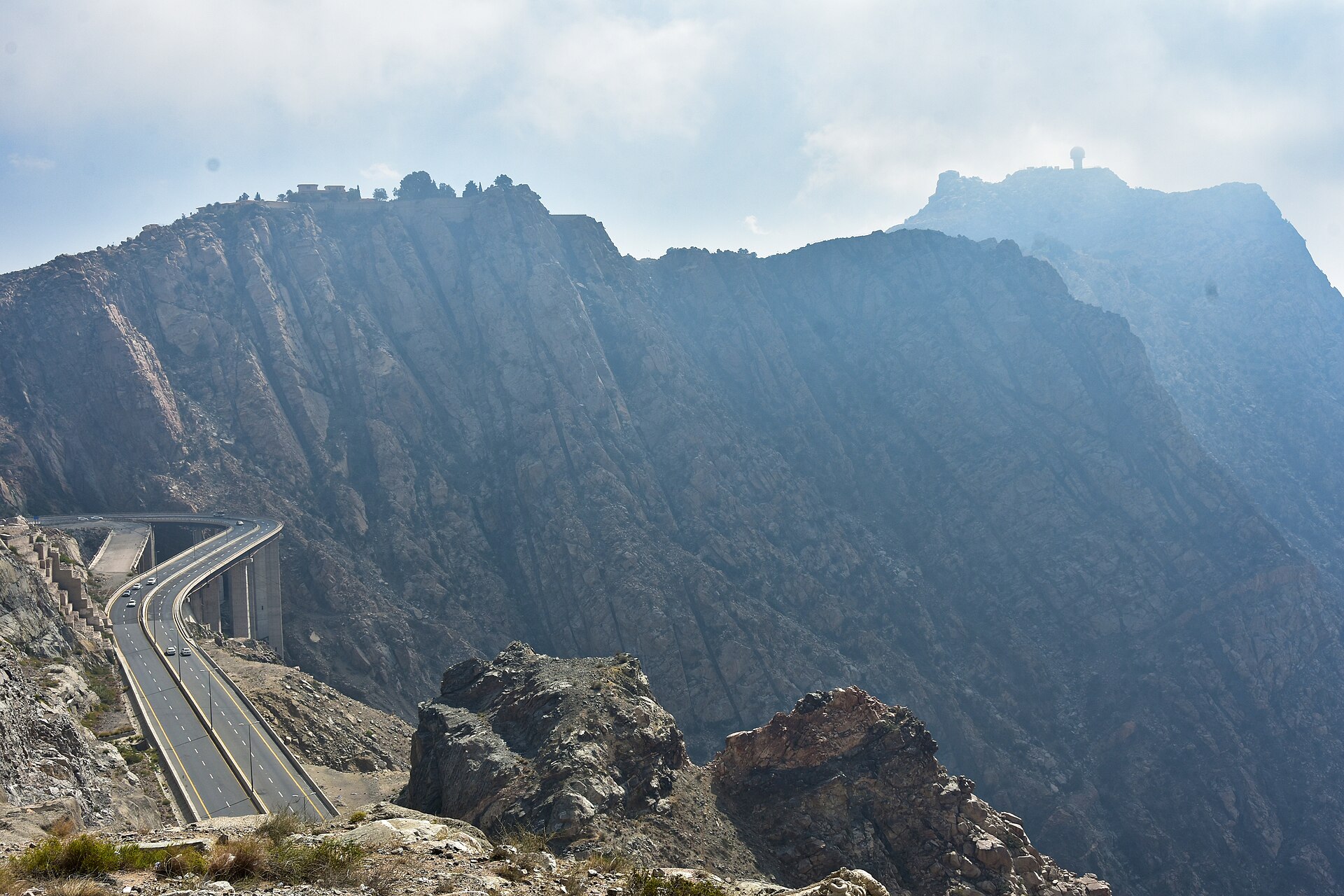
Morning: Al Hada and Al Shafa
Before leaving Taif, drive the Al Hada and Al Shafa mountain road — a series of hairpin bends climbing through granite peaks with views stretching to the Tihamah coastal plain far below. The Taif Cable Car at Al Hada offers a 15-minute aerial ride across the escarpment. Al Shafa village, at around 2,200 metres, is surrounded by fruit orchards and rose farms. If you are visiting between March and May, the Taif rose season transforms the hillsides into pink carpets.
Afternoon: Head South to Al Baha
Leave Taif by mid-afternoon on Highway 15 heading south. The road passes through Bani Saad and gradually climbs through rocky highland terrain. The landscape shifts from dry granite to greener hillsides as you enter the Al Baha region. Plan to arrive in Al Baha city or the nearby town of Baljurashi by evening. Both have hotels ranging from budget apartments to mid-range Saudi-style resorts.
Day 2: Al Baha Region — Marble Villages and Mountain Forests
Al Baha is the hidden gem of the Saudi highlands. Smaller and less developed for tourism than Abha, it rewards the patient explorer with some of the most remarkable heritage sites on the route. Read the full Al Baha guide for detailed coverage.
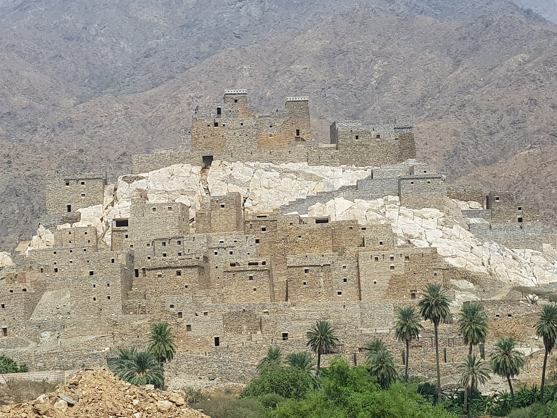
Dhee Ayn (Zee Ain) Heritage Village
The single most photogenic stop on the entire highland loop. Dhee Ayn is a fortified village of 49 multi-storey stone houses built on a white marble outcrop above banana plantations and a natural spring. Dating to the Ottoman era, it is on UNESCO’s Tentative World Heritage List. The Saudi Tourism Authority has allocated SAR 16 million for its restoration. The village sits about 20 km from Al Makhwah, reached by a winding side road that descends sharply from the highland plateau — allow 45 minutes each way from Al Baha city.
Raghadan Forest Park
Four kilometres from Al Baha city centre, Raghadan Forest Park covers 483,000 square metres of ancient juniper woodland perched on the Sarawat slopes at over 1,700 metres. Walking trails loop through the trees, and the park includes picnic areas, a traditional Sunday market, and paragliding launches with views across the Tihamah plain. Early morning visits, before the afternoon haze builds, deliver the best visibility.
The 25-Tunnel Road
Al Baha’s famous zig-zag road features 25 tunnels carved through the mountain at varying elevations, connecting the highland plateau to the Tihamah lowlands. It is a scenic attraction in its own right — the tunnels frame dramatic views of canyon walls and distant valleys. Drive it as a there-and-back excursion from Al Baha; the full descent is not necessary.
Shada Mountains
South of Al Baha, the Shada mountain range reaches 2,300 metres and harbours one of Saudi Arabia’s most biodiverse ecosystems. Ancient caves here contain prehistoric rock engravings. The mountains are home to Arabian wolves, hyenas, baboons, and — according to Saudi Wildlife Authority records — occasional Arabian leopard sightings. Access requires a short off-road drive; the area is best suited to experienced hikers.
Day 3: Al Baha to Tanomah via Al Namas
The southern half of the highland loop climbs higher and greener. Leave Al Baha after breakfast and continue south on Highway 15.
Baljurashi
Just south of Al Baha, Baljurashi sits at approximately 2,000 metres and features a well-preserved old town with traditional Hejazi stone architecture. The town hosts a weekly Friday market where highland farmers sell local honey (Sidr honey from this region commands premium prices across the Gulf), dried herbs, and handmade textiles. It is a good fuel and coffee stop.
Al Namas: The City of Fog
At 2,500 metres, Al Namas is one of the highest towns on the route. Locals call it the “City of Fog” for the thick mist that settles across its ridgeline for much of the year. The Al Namas Heritage Museum preserves traditional highland life, and the town is surrounded by terraced agricultural slopes where families have grown grain, coffee, and fruit for centuries. The terraces themselves are among the most impressive on the drive — stone walls stepping down mountainsides as far as you can see.
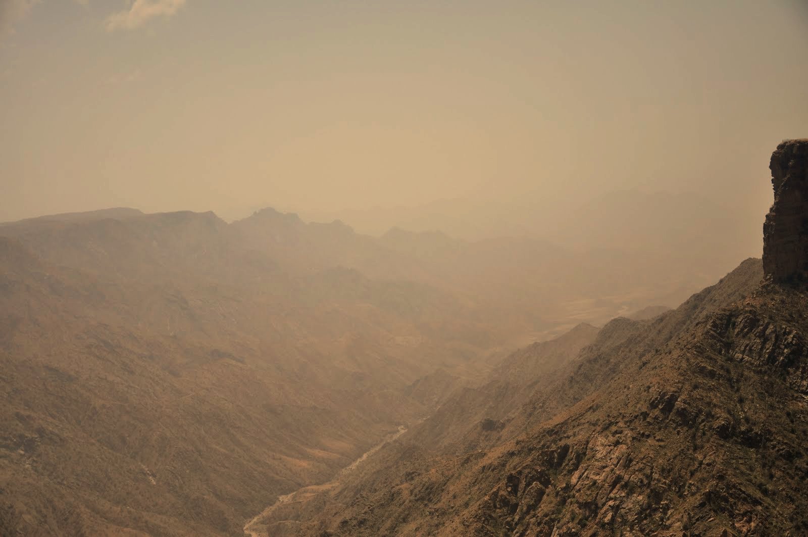
Tanomah: Juniper Forests and Waterfalls
Tanomah, at around 2,400 metres, marks the transition into the Asir region. Dense juniper forests blanket the hillsides, and after seasonal rains (typically October–November and March–April), temporary waterfalls cascade from the escarpment. The nearby Jabal Mawma reaches 2,639 metres and offers one of the best stargazing positions in the Kingdom, thanks to minimal light pollution and high altitude. Stay overnight in Tanomah or push on to Khamis Mushait, the military and commercial hub 30 km north of Abha.
Day 4: Abha and the Asir Highlands
Abha, at 2,200 metres, is the capital of the Asir region and the logical endpoint (or starting point) for the highland loop. It has the best accommodation, dining, and airport connections of any stop on the route. The full Abha and Asir travel guide covers the city in depth; here are the highlights most relevant to highland loop travellers.
Habala Hanging Village
Habala is one of the most extraordinary settlements in Arabia. A 370-year-old village built on a narrow ledge carved into a sandstone cliff, 400 metres below the plateau rim. For centuries, the only access was by rope (habala means “rope” in Arabic). A cable car built in the 1990s now carries visitors down to the village, where restored stone houses cling to the cliff face above terraced gardens. Habala is approximately one hour south of Abha. Go early in the morning before cloud cover obscures the valley views.
Jabal Sawda (Al Souda)
At approximately 3,000 metres, Jabal Sawda is the highest point in Saudi Arabia. The drive up from Abha takes about 35 minutes and ends at a ridgeline viewpoint looking across successive mountain chains fading into blue haze. The Soudah Peaks Development, a PIF-backed project valued at $7.7 billion, is building 2,700 hotel rooms, restaurants, and cable car systems here, with Phase 1 expected to open around 2027. For now, the peak is undeveloped and all the more impressive for it.
Rijal Almaa Heritage Village
Connected to the Al Souda area by a winding road (and eventually by cable car under the Soudah Peaks project), Rijal Almaa is a 900-year-old village of multi-storey stone tower houses decorated with vivid mineral pigments — whites, reds, yellows, and blues. Now operating as a heritage museum, the village preserves traditional Asiri domestic life and architecture. It is one of the most photographed sites in southern Saudi Arabia.
Abha Cable Car
The Abha Cable Car connects Al Souda mountain to Rijal Almaa village, crossing deep valleys with views of the Tihamah plain far below. The ride takes approximately 20 minutes and is one of the most scenic cable car journeys anywhere in the Middle East.
Practical Information
Best Time to Drive
The ideal window is October to March. Temperatures at altitude range from 10–25°C during the day, nights can drop to near freezing above 2,500 metres, and skies are generally clear. Avoid June to August: the highlands are cooler than the Saudi lowlands (which is why Saudis flock here as a summer escape), but dense fog frequently closes in above 2,000 metres, reducing visibility on mountain roads to under 50 metres.
Road Conditions and Driving Tips
Highway 15 is fully paved and in good condition throughout. However, expect sharp curves, steep gradients, and occasional rockfall debris. Use lower gears on long descents to save your brakes. Watch for stray livestock, especially near villages at dawn and dusk. Speed cameras are present on this route — Saudi Arabia’s speed camera network is extensive and fines arrive by SMS. Avoid driving after dark on unfamiliar mountain sections. Read the full Saudi Arabia driving rules guide before setting out.
Fuel and Supplies
Petrol stations are available in every major town: Taif, Al Baha, Baljurashi, Al Namas, Tanomah, Khamis Mushait, and Abha. Fuel is cheap by international standards (around SAR 2.33/litre for 91 octane). Fill up in each town regardless — the stretches between settlements are long enough that running low on fuel in an area with no mobile signal is not a situation you want.
Accommodation
The three best-served stops for hotels are Taif, Al Baha, and Abha. Taif has the widest range, from international chains to budget apartments. Al Baha has comfortable mid-range options. Abha has the most developed highland hospitality infrastructure, including mountain resorts. In Tanomah and Al Namas, options are more limited — local furnished apartments and small hotels predominate. Booking in advance is recommended during Saudi school holidays and the summer season (June–September), when highland towns fill with domestic tourists.
Mobile Connectivity
STC and Mobily both provide coverage in all towns along the route, but signal drops frequently in deep valleys and remote stretches between towns. Download offline maps before departure. A Saudi SIM card from STC generally offers the strongest highland coverage.
What to Pack
Layered clothing is essential. Mornings and evenings above 2,000 metres can be genuinely cold (5–10°C), while midday sun at altitude is strong. Bring a warm fleece or jacket, sunscreen, sunglasses, and sturdy walking shoes for village and forest excursions. A full Saudi Arabia packing list covers everything else.
Suggested 4-Day Itinerary
| Day | Base | Highlights |
|---|---|---|
| 1 | Taif | Al Hada mountain road, Taif Cable Car, Al Shafa village, rose gardens (seasonal). Depart late afternoon for Al Baha. |
| 2 | Al Baha / Baljurashi | Dhee Ayn marble village, Raghadan Forest Park, 25-tunnel road, Shada Mountains viewpoint. Baljurashi Friday market (if timing aligns). |
| 3 | Tanomah / Khamis Mushait | Al Namas terraces and heritage museum, Tanomah juniper forests, mountain viewpoints. Evening arrival in Khamis Mushait or Abha. |
| 4 | Abha | Habala hanging village (morning), Jabal Sawda peak drive, Rijal Almaa heritage village, Abha Cable Car. Fly out from Abha airport. |
Loop option: To make this a true loop, drive from Abha down to Jizan on the Red Sea coast (3 hours), then return north along the coastal Tihamah road to Taif (8–10 hours). This adds dramatic altitude changes — from 3,000 m to sea level and back — but requires an extra 2–3 days and crosses through some of Saudi Arabia’s hottest terrain.
Getting There and Away
Taif (start): Taif Regional Airport (TIF) receives domestic flights from Riyadh, Jeddah, and Dammam on Saudia, flynas, and flyadeal. Alternatively, drive from Jeddah via the spectacular Al Hada escarpment road (1.5 hours, 85 km). See the domestic flights guide for booking tips.
Abha (end): Abha Regional Airport (AHB) has daily flights to Riyadh and Jeddah. Khamis Mushait, 30 km north of Abha, is the main commercial hub if you need to arrange onward travel.
Car rental: All major Saudi rental companies (Hanco, Theeb, Budget, Lumi) operate in both Taif and Abha airports. One-way drop-off between cities is typically available for a surcharge of SAR 200–500. Full details in the Saudi Arabia car rental guide.
Explore More Saudi Arabia Travel Guides
- Abha and Asir Travel Guide — Complete guide to Abha, Al Souda, Habala, and the Asir highlands
- Taif Travel Guide — City of Roses, mountain resorts, and ancient poetry
- Al Baha Guide — Saudi Arabia’s green highland hidden gem
- Saudi Arabia Hiking Guide — Trails, mountains, and canyons across the Kingdom
- Mountain Retreats and Cool Destinations — Where to escape the Saudi summer heat
- Saudi Arabia Travel Guide 2026 — The complete guide to visiting the Kingdom
- Saudi Arabia Visa Guide — Every visa type explained